NASA Sees Cyclone Tim Develop in the Coral Sea
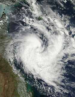
NASA's Aqua satellite captured a visible image of newborn Tropical Cyclone Tim in the Coral Sea on March 14, 2013 at 04:05 UTC (12:05 a.m. EDT). Note the large band of thunderstorms wrapping into the center from the south and east. Credit: NASA Goddard MODIS Rapid Response Team<br>
The Moderate Resolution Imaging Spectroradiometer (MODIS) instrument aboard NASA's Aqua satellite captured a visible image of Tropical Cyclone Tim in the Coral Sea on March 13, 2013 at 04:05 UTC (12:05 a.m. EDT).
The MODIS image showed a large band of thunderstorms wrapping into the center of circulation from the south and east. Cyclone Tim's northeastern quadrant was brushing Papua New Guinea, and the western quadrant was brushing Queensland Australia's east coast. The MODIS image was created by the MODIS Rapid Response Team at NASA's Goddard Space Flight Center in Greenbelt, Md.
The Joint Typhoon Warning Center noted that animated infrared satellite imagery indicated that the low-level center is consolidating and Tim is showing improved deep convective banding of thunderstorms. An eye was spotted using microwave imagery.
On March 14 at 0900 UTC (5 a.m. EDT), Tim was located 15.2 south latitude and 150.3 east longitude, just 80 nautical miles north of Willis Island, Australia (which is located east of the mainland, Queensland). Maximum sustained winds are near 50 knots (57.5 mph/92.6 kph), and Tim is expected to intensify over the next couple of days before weakening.
Willis Island surface observations from early on March 14 showed peak sustained winds of 37 knots (42.5 mph/68.5 kph) gusting to 45 knots (51.7 mph/83.3 kph).
Tim is expected to move southeast, and pass east of Willis Island, then turn toward the west like a boomerang and head toward Queensland.
Text Credit: Rob Gutro
NASA's Goddard Space Flight Center, Greenbelt, Md.
Media Contact
All latest news from the category: Earth Sciences
Earth Sciences (also referred to as Geosciences), which deals with basic issues surrounding our planet, plays a vital role in the area of energy and raw materials supply.
Earth Sciences comprises subjects such as geology, geography, geological informatics, paleontology, mineralogy, petrography, crystallography, geophysics, geodesy, glaciology, cartography, photogrammetry, meteorology and seismology, early-warning systems, earthquake research and polar research.


Newest articles

Machine learning algorithm reveals long-theorized glass phase in crystal
Scientists have found evidence of an elusive, glassy phase of matter that emerges when a crystal’s perfect internal pattern is disrupted. X-ray technology and machine learning converge to shed light…

Mapping plant functional diversity from space
HKU ecologists revolutionize ecosystem monitoring with novel field-satellite integration. An international team of researchers, led by Professor Jin WU from the School of Biological Sciences at The University of Hong…

Inverters with constant full load capability
…enable an increase in the performance of electric drives. Overheating components significantly limit the performance of drivetrains in electric vehicles. Inverters in particular are subject to a high thermal load,…

