NASA Sees Cyclone Irina Weaker in Mozambique Channel
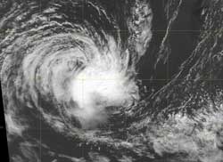
The MODIS instrument on NASA's Aqua satellite captured this visible image of Cyclone Irina on March 9 at 1048 UTC (5:48 a.m. EST). The strongest part of the storm is south of the center, and wind shear is now taking a toll on the storm's strength. Credit: NRL/NASA <br>
On March 8 at 1500 UTC (10 a.m. EST), Irina's winds had finally dropped below 45 knots (51.7 mph/83.3 kph) to 35 knots (40.2 mph/64.8 kph) making it a minimal tropical storm. Irina was still in the southern Mozambique Channel, centered near 29.5 South and 37.8 East. That is about 350 miles southeast of Maputo, Mozambique. Irina is moving to the west at 8 knots (9.2 mph/14.8 kph).
The Moderate Resolution Imaging Spectroradiometer (MODIS) instrument on NASA's Aqua satellite captured this visible image of Cyclone Irina on March 9 at 1048 UTC (5:48 a.m. EST) that showed the bulk of clouds and showers south of the center of circulation, with some outer bands of thunderstorms to the west.
Infrared satellite imagery shows that the strongest thunderstorms, located in the southeastern quadrant have weakened and are being pushed away from the center from wind shear. Once a tropical cyclone is no longer “stacked” vertically on top of itself, it weakens, and that's what is happening to Irina.
In addition to increased wind shear, sea surface temperatures are below the 80 degree Fahrenheit threshold (26.6 C) needed to maintain a tropical cyclone, so the cooler waters are preventing evaporation and energy feeding into the storm.
The Joint Typhoon Warning Center expects that Irina will finally dissipate at sea over the weekend.
Text Credit: Rob Gutro
NASA Goddard Space Flight Center, Greenbelt, Md.
Media Contact
More Information:
http://www.nasa.govAll latest news from the category: Earth Sciences
Earth Sciences (also referred to as Geosciences), which deals with basic issues surrounding our planet, plays a vital role in the area of energy and raw materials supply.
Earth Sciences comprises subjects such as geology, geography, geological informatics, paleontology, mineralogy, petrography, crystallography, geophysics, geodesy, glaciology, cartography, photogrammetry, meteorology and seismology, early-warning systems, earthquake research and polar research.


Newest articles

Solving the riddle of the sphingolipids in coronary artery disease
Weill Cornell Medicine investigators have uncovered a way to unleash in blood vessels the protective effects of a type of fat-related molecule known as a sphingolipid, suggesting a promising new…
Rocks with the oldest evidence yet of Earth’s magnetic field
The 3.7 billion-year-old rocks may extend the magnetic field’s age by 200 million years. Geologists at MIT and Oxford University have uncovered ancient rocks in Greenland that bear the oldest…

Decisive breakthrough for battery production
Storing and utilising energy with innovative sulphur-based cathodes. HU research team develops foundations for sustainable battery technology Electric vehicles and portable electronic devices such as laptops and mobile phones are…

