NASA sees compact Tropical Storm Damrey approaching southern Japan
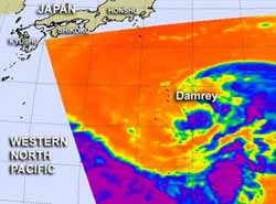
NASA's Aqua satellite passed over Tropical Storm Damrey on July 29 at 11:21 p.m. EDT and the AIRS instrument captured an infrared image of the storm. It showed that strong, high, cold cloud tops of thunderstorms (purple) were in a tight circle around the center of circulation.<br>Credit: Credit: NASA JPL, Ed Olsen<br>
NASA's Aqua satellite passed over Tropical Storm Damrey on July 30 at 03:21 UTC (July 29 at 11:21 p.m. EDT) and the Atmospheric Infrared Sounder (AIRS) instrument captured an infrared image of the storm. It showed that strong, high, cold cloud tops of thunderstorms were in a tight circle around the center of circulation.
There were bands of thunderstorms mostly north and east of the center of circulation. Some of the thunderstorm cloud tops were so high that they were as cold as -63 Fahrenheit/-52 Celsius. The circle of thunderstorms appears compact in the infrared imagery.
Damrey formed as a depression on July 28. By July 30, Damrey reached tropical storm status. Damrey's maximum sustained winds were near 45 knots (51.7 mph/83.3 kmh) at 11 a.m. EDT (1500 UTC) on July 30. Tropical-storm-force winds extend out 50 nautical miles (57.5 miles/92.6 km) from the center, making the storm just over 100 miles (115 miles/185 km) in diameter. Damrey was located about 175 nautical miles (201.4 miles/324 km) east-northwest of Iwo To, near 26.3 North and 143.6 East. It is moving to the west-northwest at 5 knots (5.7 mph/9.2 kmh).
Forecasters at the Joint Typhoon Warning Center expect Damrey to track to the west-northwest over the next three days. It is currently expected to strengthen and then weaken before it makes landfall north of Shanghai, China on August 3.
Media Contact
More Information:
http://www.nasa.govAll latest news from the category: Earth Sciences
Earth Sciences (also referred to as Geosciences), which deals with basic issues surrounding our planet, plays a vital role in the area of energy and raw materials supply.
Earth Sciences comprises subjects such as geology, geography, geological informatics, paleontology, mineralogy, petrography, crystallography, geophysics, geodesy, glaciology, cartography, photogrammetry, meteorology and seismology, early-warning systems, earthquake research and polar research.


Newest articles

Properties of new materials for microchips
… can now be measured well. Reseachers of Delft University of Technology demonstrated measuring performance properties of ultrathin silicon membranes. Making ever smaller and more powerful chips requires new ultrathin…

Floating solar’s potential
… to support sustainable development by addressing climate, water, and energy goals holistically. A new study published this week in Nature Energy raises the potential for floating solar photovoltaics (FPV)…

Skyrmions move at record speeds
… a step towards the computing of the future. An international research team led by scientists from the CNRS1 has discovered that the magnetic nanobubbles2 known as skyrmions can be…

