NASA sees cloud top temperatures warming in Cyclone Victor
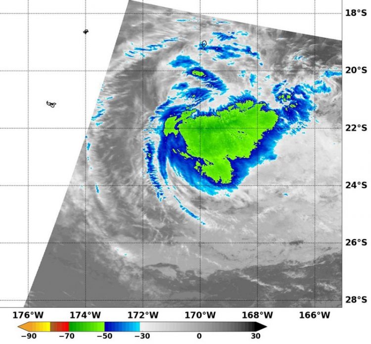
This infrared image from the MODIS instrument aboard NASA's Aqua satellite shows coldest clouds tops (-63F/-53C) and strongest storms southeast of the center of Tropical Cyclone Victor on Jan. 21 at 1210 UTC. Credits: NASA/NRL
Warmer cloud top temperatures means that convection (rising air that leads to the development of thunderstorms that make up a tropical cyclone) has started to weaken.
Infrared data from the MODIS (Moderate Resolution Imaging Spectroradiometer) instrument aboard NASA's Aqua satellite showed coldest clouds tops had warmed to near minus 63 degrees Fahrenheit (minus 53 degrees Celsius) southeast of Victor's center on Jan. 21 at 1210 UTC (7:10 a.m. EST).
When cloud tops warm on infrared satellite imagery, it means they are not being pushed as high in the troposphere (lowest level of the atmosphere).
That's an indication that the storm has less uplift and becomes weaker. JTWC forecasters noted “animated enhanced infrared satellite imagery depicts a decoupling low-level circulation center, with warming cloud-tops.”
At 0900 UTC (4 a.m. EST), Tropical Cyclone Victor was still a Category One hurricane on the Saffir-Simpson hurricane wind scale. Maximum sustained winds were near 65 knots (75 mph/120 kph).
Tropical cyclone Victor was centered near 21.5 degrees south latitude and 171.0 degrees west longitude, about 432 miles south of Pago Pago, American Samoa. Victor was moving to the west at 7 knots (8 mph/12.9 kph).
Warnings were issued from the Fua'amotu Tropical Cyclone Warning Centre in Tonga on Jan. 21. In Tonga, a tropical cyclone warning remains inforce for Ha'apai, Tongatapu and 'Eua. A gale warning remains inforce for Ha'apai, Tongatapu and 'Eua. A strong wind warning remains inforce for Vavau.
A heavy damaging swells remain in force for all Tonga waters. For the updated forecast for Tonga, visit: http://www.
Victor is moving west and is forecast to weaken steadily over the next few days before turning south. Victor is expected to dissipate by January 24.
Media Contact
All latest news from the category: Earth Sciences
Earth Sciences (also referred to as Geosciences), which deals with basic issues surrounding our planet, plays a vital role in the area of energy and raw materials supply.
Earth Sciences comprises subjects such as geology, geography, geological informatics, paleontology, mineralogy, petrography, crystallography, geophysics, geodesy, glaciology, cartography, photogrammetry, meteorology and seismology, early-warning systems, earthquake research and polar research.


Newest articles

Silicon Carbide Innovation Alliance to drive industrial-scale semiconductor work
Known for its ability to withstand extreme environments and high voltages, silicon carbide (SiC) is a semiconducting material made up of silicon and carbon atoms arranged into crystals that is…

New SPECT/CT technique shows impressive biomarker identification
…offers increased access for prostate cancer patients. A novel SPECT/CT acquisition method can accurately detect radiopharmaceutical biodistribution in a convenient manner for prostate cancer patients, opening the door for more…

How 3D printers can give robots a soft touch
Soft skin coverings and touch sensors have emerged as a promising feature for robots that are both safer and more intuitive for human interaction, but they are expensive and difficult…

