NASA sees Chantal weaken to a remnant
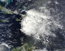
NASA's Terra satellite captured this visible image of Chantal when it was a tropical storm over Hispaniola on July 10 at 15:20 UTC (11:20 a.m. EDT). Credit:<br><br>Credit: NASA Goddard MODIS Rapid Response Team<br>
The Moderate Resolution Imaging Spectroradiometer or MODIS instrument that flies aboard NASA's Terra satellite captured a visible image of Chantal when it was a tropical storm over Hispaniola on July 10 at 15:20 UTC (11:20 a.m. EDT). At that time, Chantal's northern quadrant covered the Dominican Republic and eastern Haiti while the center of the storm remained south of Hispaniola.
Tropical Storm Chantal ran into some strong upper-level winds that tore the storm apart. The National Hurricane Center (NHC) issued the final bulletin on Chantal on July 10 at 2100 UTC (5 p.m. EDT). At that time it was considered a remnant low pressure area with maximum sustained winds near 40 knots. Tropical-storm-force winds were occurring over a large area south of Hispaniola. It was centered near 16.5 north latitude and 73.7 west longitude, about 230 miles east-southeast of Kingston, Jamaica and moving to the west at 25 knots. All warnings were cancelled.
NHC noted that Chantal was no longer considered a tropical cyclone and that its remnants would bring rainfall totals between 3 and 6 inches to Hispaniola, Jamaica, central and eastern Cuba as well as the southeastern Bahamas.
On July 11, the remnant low and its associated showers and thunderstorms stretched from Hispaniola northward to the southeastern and central Bahamas and the adjacent Atlantic waters. Some heavy rains and gusty winds were expected to spread over the southeastern and central Bahamas today, July 11, and Friday, July 12, according to NHC.
NOAA's GOES-13 satellite has been capturing images of Chantal's demise. NASA's GOES Project at the NASA Goddard Space Flight Center in Greenbelt, Md. created an image on July 11 at 1445 UTC (10:45 a.m. EDT) that showed showers and thunderstorms associated with the low stretched from Hispaniola north into the Bahamas. There was also another area of thunderstorms over eastern Cuba.
Because the upper-level winds are still strong, the NHC noted that there are no signs of regeneration and the forecast calls for the winds to remain hostile for significant development. So, NHC has given Chantal's remnants just a 20 percent of becoming a tropical cyclone again over the next 48 hours.
Media Contact
More Information:
http://www.nasa.govAll latest news from the category: Earth Sciences
Earth Sciences (also referred to as Geosciences), which deals with basic issues surrounding our planet, plays a vital role in the area of energy and raw materials supply.
Earth Sciences comprises subjects such as geology, geography, geological informatics, paleontology, mineralogy, petrography, crystallography, geophysics, geodesy, glaciology, cartography, photogrammetry, meteorology and seismology, early-warning systems, earthquake research and polar research.


Newest articles

Silicon Carbide Innovation Alliance to drive industrial-scale semiconductor work
Known for its ability to withstand extreme environments and high voltages, silicon carbide (SiC) is a semiconducting material made up of silicon and carbon atoms arranged into crystals that is…

New SPECT/CT technique shows impressive biomarker identification
…offers increased access for prostate cancer patients. A novel SPECT/CT acquisition method can accurately detect radiopharmaceutical biodistribution in a convenient manner for prostate cancer patients, opening the door for more…

How 3D printers can give robots a soft touch
Soft skin coverings and touch sensors have emerged as a promising feature for robots that are both safer and more intuitive for human interaction, but they are expensive and difficult…

