NASA sees bitter cold cloud tops in newborn Tropical Storm Carlotta
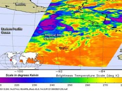
NASA's AIRS instrument data showed on June 14, at 0723 UTC (3:23 a.m. EDT/12:23 a.m. PDT) that Tropical Storm Carlotta's low-level circulation center had consolidated and shows improved convective banding (of thunderstorms). Credit: Credit: NASA/JPL, Ed Olsen<br>
NASA's Aqua satellite data showed that the cloud top temperatures in newborn Tropical Storm Carlotta became colder overnight and continue to grow colder as the low pressure area formely known as System 94E strengthened into a tropical storm. Carlotta is even expected to strengthen further and become a hurricane.
Because Carlotta is expected to continue strengthening, the government of Mexico has issued a hurricane warning for the Pacific coast of Mexico From Salina Cruz to Punta Maldonado. A hurricane watch is also in effect for the Pacific coast of Mexico west of Punta Maldonado to Acapulco and east of Salina Cruz to Barra De Tonala.
Forecasters look at data from the Atmospheric Infrared Sounder (AIRS) instrument that flies on NASA's Aqua satellite. When cloud temperatures get colder, it means that clouds are getting higher. The lowest temperatures in Carlotta were as cold as or colder than 220 degrees Kelvin or minus 63 degrees Fahrenheit (-52 Celsius). The data from AIRS is also used to create an accurate 3-D map of atmospheric temperature, water vapor and clouds, all of which are helpful to forecasters.
At 11 a.m. EDT (8 a.m. PDT) Tropical Storm Carlotta's maximum sustained winds were near 45 mph (75 kph), and further strengthening is expected in the warm waters along the western coast of Mexico. Carlotta is expected to become a hurricane on June 15, according to the National Hurricane Center. Currently, Carlotta is located about 385 miles (620 km) south-southeast of Puerto Angel and 590 miles (950 km) southeast of Acapulco, Mexico. Carlotta is moving northwest near 9 mph (15 kph) and is expected to continue for the next couple of days. The storm should be near the Pacific coast of Mexico on Friday and move near the coast Friday night and Saturday, according to the National Hurricane Center.
That means that hurricane conditions are expected in the warning area by Friday night, June 15 and those conditions will continue on June 16, Saturday. Storm surge, heavy rainfall, flooding and mudslides are also possible. Isolated rainfall totals can reach 10-12 inches (250-300 mm) over the Mexican states of Guerrero, Oaxaca, Chiapas and southern Guatemala.
Media Contact
More Information:
http://www.nasa.govAll latest news from the category: Earth Sciences
Earth Sciences (also referred to as Geosciences), which deals with basic issues surrounding our planet, plays a vital role in the area of energy and raw materials supply.
Earth Sciences comprises subjects such as geology, geography, geological informatics, paleontology, mineralogy, petrography, crystallography, geophysics, geodesy, glaciology, cartography, photogrammetry, meteorology and seismology, early-warning systems, earthquake research and polar research.


Newest articles

Properties of new materials for microchips
… can now be measured well. Reseachers of Delft University of Technology demonstrated measuring performance properties of ultrathin silicon membranes. Making ever smaller and more powerful chips requires new ultrathin…

Floating solar’s potential
… to support sustainable development by addressing climate, water, and energy goals holistically. A new study published this week in Nature Energy raises the potential for floating solar photovoltaics (FPV)…

Skyrmions move at record speeds
… a step towards the computing of the future. An international research team led by scientists from the CNRS1 has discovered that the magnetic nanobubbles2 known as skyrmions can be…

