NASA Sees Active Tropical Eastern Pacific Ocean
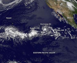
NOAA's GOES-15 satellite captured a very active Eastern Pacific ocean on Aug. 2 at 0900 UTC (5 a.m. EDT) with one hurricane and two developing tropical low pressure areas.<br>Image Credit: NASA GOES Project<br>
NOAA's GOES-15 satellite captured a very active Eastern Pacific ocean on Aug. 2 at 0900 UTC (5 a.m. EDT) with one hurricane and two developing tropical low pressure areas. System 91E is farthest west and approaching the Central Pacific, while Hurricane Gil and System 90E trail behind to the east. The GOES-15 infrared image was created at NASA's GOES Project at the NASA Goddard Space Flight Center, Greenbelt, Md.
System 91E Headed into Central Pacific Ocean
The low pressure area called “System 91E” has developed about 1,260 miles east-southeast of Hilo, Hawaii. The National Hurricane Center in Miami, Fla. and the Central Pacific Hurricane Center or CPHC in Honolulu, Hawaii are monitoring System 91E and expect any development to be slow. Because System 91E is moving into the Central Pacific Ocean it will soon become the responsibility of the CPHC. Currently, System 91E has a low chance of becoming a tropical cyclone during the next 48 hours.
Hurricane Gil Sandwiched
Hurricane Gil is sandwiched between two low pressure areas: System 91E to the west and System 90E to Gil's east. Gil appears to be inhibiting System 90E's development, but that may change if Gil weakens or moves farther away from the low.
At 5 p.m. EDT on Aug. 2, Gil's maximum sustained winds were near 85 mph/140 kph. The National Hurricane Center expects little change in strength during the next two days.
Gil was centered near 14.6 north latitude and 127.3 west longitude, about 1,275 miles/2,050 km west-southeast of the southern tip of Baja California, Mexico. Gil is moving west at 13 mph/20 kph and this motion is expected to continue with some decrease in forward speed during the next two days. The estimated minimum central pressure is 985 millibars.
In the GOES-15 satellite imagery Gil appears less organized and the area of strongest convection (rising air that forms the thunderstorms that make up the tropical cyclone) has been shrinking. Precipitable water imagery shows that drier air is wrapping into the eastern side of the storm and is likely the cause of the diminished organization.
Over the weekend of Aug. 3 and 4, the NHC expects slow weakening when Gil moves over progressively cooler water and into an environment of slightly stronger wind shear.
System 90E Being Affected by Hurricane Gil
Low pressure area called “System 90E” is still chasing Hurricane Gil. Located east of Gil, it is located about 900 miles southwest of the southern tip of the Baja California Peninsula of Mexico. Gil is moving westward at about 10 to 15 mph.
System 90E is producing disorganized thunderstorms, but NHC noted that if Hurricane Gil weakens, System 90E get a chance to develop. Gil's close proximity to System 90E is adversely affecting the storm's ability to organize. System 90E was given a 30 percent or medium chance of becoming a tropical cyclone over the next two days, and a higher chance over the next 5 days.
Rob Gutro
NASA's Goddard Space Flight Center, Greenbelt, Md.
Media Contact
All latest news from the category: Earth Sciences
Earth Sciences (also referred to as Geosciences), which deals with basic issues surrounding our planet, plays a vital role in the area of energy and raw materials supply.
Earth Sciences comprises subjects such as geology, geography, geological informatics, paleontology, mineralogy, petrography, crystallography, geophysics, geodesy, glaciology, cartography, photogrammetry, meteorology and seismology, early-warning systems, earthquake research and polar research.


Newest articles

Machine learning algorithm reveals long-theorized glass phase in crystal
Scientists have found evidence of an elusive, glassy phase of matter that emerges when a crystal’s perfect internal pattern is disrupted. X-ray technology and machine learning converge to shed light…

Mapping plant functional diversity from space
HKU ecologists revolutionize ecosystem monitoring with novel field-satellite integration. An international team of researchers, led by Professor Jin WU from the School of Biological Sciences at The University of Hong…

Inverters with constant full load capability
…enable an increase in the performance of electric drives. Overheating components significantly limit the performance of drivetrains in electric vehicles. Inverters in particular are subject to a high thermal load,…

