NASA Sees a Wide-Eyed Super Typhoon Jelawat
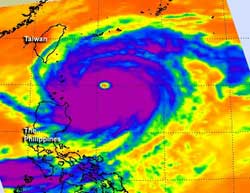
This infrared image was created from AIRS data of Super Typhoon Jelawat on Sept. 27 at 0459 UTC as the storm moves away from the northern Philippines. A thick area of strong thunderstorms with very cold cloud top temperatures appear in purple surrounding at 36 nautical-mile wide eye.<br>Credit: NASA JPL/Ed Olsen <br>
The latest infrared image from the Atmospheric Infrared Sounder (AIRS) instrument that flies on NASA's Aqua satellite shows a clear eye in Typhoon Jelawat on Sept. 25.
The cloud top temperatures of the thunderstorms surrounding the eye exceed -63 Fahrenheit (-52 Celsius) indicating that they are very powerful and heavy rainmakers.. Jelawat also has a rounded shape indicating that circulation is strong and symmetrical
On Sept. 25, Super Typhoon Jelawat's maximum sustained winds were near 95 knots (109 mph/176 kmh). It was located about 390 nautical miles (449 miles/722 km) south-southwest of Kadena Air Base, Okinawa, Japan, near 21.4 North and 124.0 East. Jelawat was moving north-northwest at 9 knots(10.3 mph/16.6 kmh) and generating extreme seas with wave heights to 48 feet (14.6 meters).
Like Ewiniar, Jelawat is also expected to affect Kadena Air Base and its center is forecast to move very close to the island. The Joint Typhoon Warning Center noted “Regardless of the exact track near Okinawa, Jelawat is a 300 nautical mile wide system with a large eye and eyewall and will maintain 100 plus knot winds (115 mph/185 kmh) through (48 hours from Sept. 27 at 11 a.m. EDT/1500 UTC) due to continued favorable environmental conditions.”
Jelawat is then expected to continue north-northeast and make landfall just south of Kyoto, Japan on Sept. 30.
Text credit: Rob Gutro
NASA's Goddard Space Flight Center, Greenbelt, Md.
Media Contact
All latest news from the category: Earth Sciences
Earth Sciences (also referred to as Geosciences), which deals with basic issues surrounding our planet, plays a vital role in the area of energy and raw materials supply.
Earth Sciences comprises subjects such as geology, geography, geological informatics, paleontology, mineralogy, petrography, crystallography, geophysics, geodesy, glaciology, cartography, photogrammetry, meteorology and seismology, early-warning systems, earthquake research and polar research.


Newest articles

Silicon Carbide Innovation Alliance to drive industrial-scale semiconductor work
Known for its ability to withstand extreme environments and high voltages, silicon carbide (SiC) is a semiconducting material made up of silicon and carbon atoms arranged into crystals that is…

New SPECT/CT technique shows impressive biomarker identification
…offers increased access for prostate cancer patients. A novel SPECT/CT acquisition method can accurately detect radiopharmaceutical biodistribution in a convenient manner for prostate cancer patients, opening the door for more…

How 3D printers can give robots a soft touch
Soft skin coverings and touch sensors have emerged as a promising feature for robots that are both safer and more intuitive for human interaction, but they are expensive and difficult…

