NASA sees a 'hot tower' in newborn eastern Pacific Tropical Depression 2E

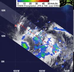
When NASA's TRMM satellite passed over TD02E on May 21, 2012, at 08:50 UTC (4:50 a.m. EDT), data revealed a hot tower over 15 kilometers (9.3 miles) high. TRMM also measured rainfall within the tropical depression, and found that isolated areas of heavy rain (falling at a rate of 2 inches/50 mm per hour (appearing in red)) were seen in the northwestern quadrant of the storm. Light to moderate rainfall was falling at a rate between .78 inches and 1.57 inches per hour (20 to 40 mm).<br><br>Credit: NASA/TRMM, Hal Pierce<br>
A “hot tower” is a rain cloud that reaches at least to the top of the troposphere, the lowest layer of the atmosphere. It extends approximately nine miles (14.5 km) high in the tropics. These towers are called “hot” because they rise to such altitude due to the large amount of latent heat.
Water vapor releases this latent heat as it condenses into liquid. NASA scientists, using data from the Tropical Rainfall Measuring Mission (TRMM) satellite, found that a tropical cyclone with a hot tower in its eyewall was twice as likely to intensify within the next six hours, than a cyclone that lacked a tower. The “eyewall” is the ring of clouds around a cyclone's central eye.
When NASA's TRMM satellite passed over TD02E on May 21, 2012 at 08:50 UTC (4:50 a.m. EDT), data revealed a hot tower over 15 kilometers (9.3 miles) high. That's an indication that the storm is going to intensify, and that's one factor that forecasters at the National Hurricane Center are using in their forecast, which calls for TD02E to become a tropical storm later in the day on May 21.
TRMM also measured rainfall within the tropical depression, and found that isolated areas of heavy rain (falling at a rate of 2 inches/50 mm per hour) were seen in the northwestern quadrant of the storm. Light-to-moderate rainfall was falling throughout the rest of the storm.
At 5 a.m. EDT on May 21, TD02E had maximum sustained winds near 35 mph. It was centered about 520 miles (835 km) south of Acapulco, Mexico, near 9.4 North and 100.1 West. It was moving to the west near 6 mph (9 kph) and had a minimum central pressure of 1005 millibars.
The forecasters at the National Hurricane center predict TD 02E will turn to the west-northwest and northwest, while speeding up. TD02E is also expected to strengthen into a tropical storm, and into a hurricane later in the week. Residents of west central Mexico should monitor the progress of this storm.
Media Contact
More Information:
http://www.nasa.govAll latest news from the category: Earth Sciences
Earth Sciences (also referred to as Geosciences), which deals with basic issues surrounding our planet, plays a vital role in the area of energy and raw materials supply.
Earth Sciences comprises subjects such as geology, geography, geological informatics, paleontology, mineralogy, petrography, crystallography, geophysics, geodesy, glaciology, cartography, photogrammetry, meteorology and seismology, early-warning systems, earthquake research and polar research.
Newest articles

Machine learning algorithm reveals long-theorized glass phase in crystal
Scientists have found evidence of an elusive, glassy phase of matter that emerges when a crystal’s perfect internal pattern is disrupted. X-ray technology and machine learning converge to shed light…

Mapping plant functional diversity from space
HKU ecologists revolutionize ecosystem monitoring with novel field-satellite integration. An international team of researchers, led by Professor Jin WU from the School of Biological Sciences at The University of Hong…

Inverters with constant full load capability
…enable an increase in the performance of electric drives. Overheating components significantly limit the performance of drivetrains in electric vehicles. Inverters in particular are subject to a high thermal load,…


