NASA sees 10-mile-high thunderstorms in Hurricane Henriette
TRMM is able to measure rainfall occurring in a storm from space. Rainfall is derived from TRMM's Microwave Imager and Precipitation Radar instruments. TRMM's PR instrument measured rain falling at the rate of over 55.46 mm (~2.2 inches) per hour a towering thunderstorm near Henriette's center.<br><br>Credit: SSAI/NASA, Hal Pierce<br>
The higher the thunderstorms are, the more powerful the uplift in the air, and more powerful the thunderstorms. Thunderstorms that reach 10 miles high, like some of the ones seen in Hurricane Henriette tend to drop heavy rainfall, and NASA's Tropical Rainfall Measuring Mission or TRMM satellite confirmed that.
The TRMM satellite flew over the eastern Pacific Ocean on August 6, 2013 at 0233 UTC (~5:33 p.m. Hawaii local time) collecting data for low sun angle views of Hurricane Henriette. A visible/infrared image created by TRMM data showed shadows cast by towering thunderstorms on the northeastern side of Henriette's eye wall.
TRMM is able to measure rainfall occurring in a storm from its orbit in space. Rainfall is derived from TRMM's Microwave Imager and Precipitation Radar instruments. TRMM's PR instrument measured rain falling at the rate of over 55.46 mm (~2.2 inches) per hour a towering thunderstorm near Henriette's center.
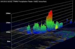
At NASA's Goddard Space Flight Center in Greenbelt, Md. the TRMM team used the satellite's data to create 3-D images and animations. One 3-D image looking toward the east from TRMM PR data revealed that towering storms in the northeastern side of Henriette's eye were reaching heights of almost 16.75km (~10.41 miles). This kind of chimney cloud, also called a “hot tower” (as it releases a huge quantity of latent heat by condensation) can play a part in the formation or intensification of tropical cyclones. Intense rainfall in Henriette's eye wall was returning values greater than 48.7dBZ to the TRMM satellite.
At 11 a.m. EDT on Aug. 7, Hurricane Henriette's maximum sustained winds were near 85 mph/140 kph, and little change in strength is expected today, while weakening is expected to begin tomorrow, Aug. 8. The center of Hurricane Henriette was located near latitude 16.2 north and longitude 134.9 west, about 1,350 miles/2,170 km east of Hilo, Hawaii. Henriette is moving toward the west-northwest near 10 mph/17 kph and is expected to continue in that direction before turning west tomorrow, Aug. 8.
This 3-D image (looking toward the east) from TRMM PR data reveals that towering storms in the northeastern side of Henriette's eye were reaching height of almost 16.75km (~10.41 miles).
Media Contact
More Information:
http://www.nasa.govAll latest news from the category: Earth Sciences
Earth Sciences (also referred to as Geosciences), which deals with basic issues surrounding our planet, plays a vital role in the area of energy and raw materials supply.
Earth Sciences comprises subjects such as geology, geography, geological informatics, paleontology, mineralogy, petrography, crystallography, geophysics, geodesy, glaciology, cartography, photogrammetry, meteorology and seismology, early-warning systems, earthquake research and polar research.


Newest articles

“Nanostitches” enable lighter and tougher composite materials
In research that may lead to next-generation airplanes and spacecraft, MIT engineers used carbon nanotubes to prevent cracking in multilayered composites. To save on fuel and reduce aircraft emissions, engineers…

Trash to treasure
Researchers turn metal waste into catalyst for hydrogen. Scientists have found a way to transform metal waste into a highly efficient catalyst to make hydrogen from water, a discovery that…

Real-time detection of infectious disease viruses
… by searching for molecular fingerprinting. A research team consisting of Professor Kyoung-Duck Park and Taeyoung Moon and Huitae Joo, PhD candidates, from the Department of Physics at Pohang University…

