NASA Saw Some Power in Tropical Cyclone Gillian Before Making Landfall
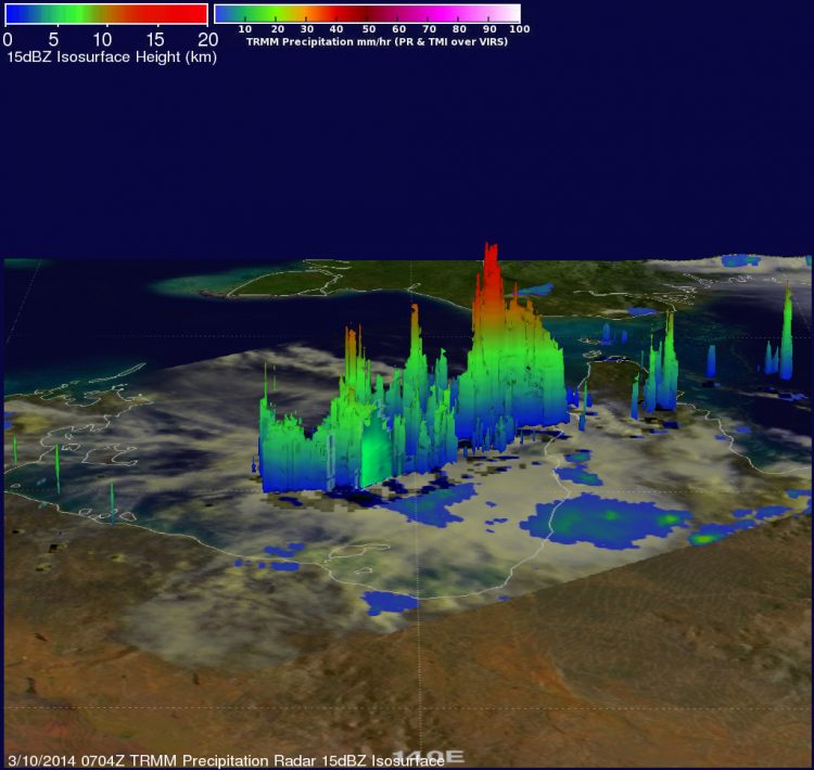
On March 10, NASA's TRMM satellite showed that some of the powerful storms within Tropical Cyclone Gillian reached heights above 16 km/~9.9 miles. Image Credit: NASA/SSAI, Hal Pierce
On March 10, NASA and JAXA's Tropical Rainfall Measuring Mission satellite called TRMM passed over Tropical Cyclone Gillian. TRMM's Precipitation Radar (PR) instrument gathered data that showed some of the powerful storms within tropical storm Gillian reached heights above 16 km/9.9 miles.
Tropical Cyclone Gillian's center still remained over land on March 11 at 0300 UTC. Maximum sustained winds were near 35 knots/40 mph/62 kph. Gillian was centered near 15.5 south and 141.7 east, over the Western Cape York Peninsula of Queensland and still 163 nautical miles/187.6 miles/301.9 km east-northeast of Mornington Island, Australia. It was moving to the south at 5 knots/5.7 mph/9.2 kph. The Joint Typhoon Warning Center issued their final advisory on Gillian at 0300 UTC.
By 1200 UTC/8 a.m. EST on March 11, the Joint Typhoon Warning Center or JTWC noted that Gillian had become a remnant low pressure area. An area of convection persisted near 15.6 south and 141.1 east, about 100 nautical miles/115.1 miles/185.2 km east-northeast of Mornington Island.
The JTWC noted that animated infrared imagery showed that the convection over the weak low-level circulation was poorly organized. Radar imagery showed that bands of thunderstorms were fragmented over the northwestern quadrant of the low pressure area.
Surface observations today (March 11) from Mornington Island and Kowanyama showed light winds (less than 10 knots/11.5 mph/18.5 kph) and sea level air pressure values near 1009 millibars. Maximum sustained surface winds were estimated at 15 to 20 knots/17.2 to 23.0 mph/27.7 to 37.0 kph. JTWC noted that the potential for the re-development into a tropical depression or tropical storm is low over the next day.
The Australian Bureau of Meteorology does not have any current warnings in place for Gillian's remnants, but cautioned, “People from Burketown to the QLD/NT (Queensland/Northern Territory) border, including Mornington Island and Sweers Island should consider what action they will need to take if the cyclone threat increases.”
Text credit: Rob Gutro/Hal Pierce
NASA's Goddard Space Flight Center/SSAI
Media Contact
All latest news from the category: Earth Sciences
Earth Sciences (also referred to as Geosciences), which deals with basic issues surrounding our planet, plays a vital role in the area of energy and raw materials supply.
Earth Sciences comprises subjects such as geology, geography, geological informatics, paleontology, mineralogy, petrography, crystallography, geophysics, geodesy, glaciology, cartography, photogrammetry, meteorology and seismology, early-warning systems, earthquake research and polar research.


Newest articles

Properties of new materials for microchips
… can now be measured well. Reseachers of Delft University of Technology demonstrated measuring performance properties of ultrathin silicon membranes. Making ever smaller and more powerful chips requires new ultrathin…

Floating solar’s potential
… to support sustainable development by addressing climate, water, and energy goals holistically. A new study published this week in Nature Energy raises the potential for floating solar photovoltaics (FPV)…

Skyrmions move at record speeds
… a step towards the computing of the future. An international research team led by scientists from the CNRS1 has discovered that the magnetic nanobubbles2 known as skyrmions can be…

