NASA saw heavy rainfall in Tropical Cyclone Marcia
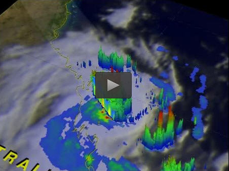
On Feb. 19, NASA-JAXA's TRMM satellite saw thunderstorm tops over 15.2 km (9.4 miles) and heavy rainfall in Marcia's eye wall. Image Credit: NASA/JAXA, Hal Pierce
Tropical Cyclone Marcia made landfall along Queensland coast between Yeppoon and St. Lawrence around 2200 UTC on Feb. 19 (5 p.m. EST U.S./Feb. 20 at 8 a.m. local time Brisbane).
The TRMM satellite exhausted its station keeping fuel in July 2014 and has been drifting downward. On Feb. 19, NASA and the Japan Aerospace Exploration Agency's TRMM satellite had an excellent view of Marcia. About six minutes after seeing Lam land falling in the Northern Territory, TRMM flew directly above category five cyclone Marcia, located off Australia's northeastern coast. TRMM's Precipitation Radar (PR) found that some very intense storms in the northwestern side of Marcia's eye wall were dropping rain at the extreme rate of 225 mm (8.8 inches) per hour.
At NASA's Goddard Space Flight Center in Greenbelt, Maryland a 3-D View of Marcia was made from TRMM's Precipitation Radar (PR) data. The 3-D image showed that some thunderstorm tops in the small but powerful tropical cyclone were reaching heights of over 15.2 km (9.4 miles).
Marcia made landfall late on Feb. 19 (U.S. Eastern Time) and is weakening rapidly. Forecasters expect that its track over land will continue weakening the system. However, Marcia's remnants will reemerge over the southern Coral Sea, but it is not expected to re-generate.
The Joint Typhoon Warning Center issued their warning for Tropical cyclone Marcia at 0900 UTC (4 a.m. EST) on Feb. 20. At that time, Marcia was centered near 23.8 south and 1506. East, about 262 nautical miles north-northwest of Brisbane, Australia. Marcia's maximum sustained winds dropped to 75 knots (86 mph/138.9 kph). Marcia weakened quickly afterward and six hours later was a remnant low pressure area.
At 1 a.m. local Brisbane time on Feb. 21 (10 a.m. EST, Feb. 20), Marcia's winds had dropped to 55 kph (34 mph) over land, making it a remnant low pressure area. There were not tropical cyclone warnings or watches in effect, but heavy rain was main concern.
The ABM noted ” Heavy rainfall is occurring about coastal and adjacent inland areas between Bundaberg and Gympie, and this area of rainfall is expected to translate southwards with the system tonight and Saturday morning. A Flood Watch is current for the area.” For updates on the storm, visit ABM's website: http://www.
Media Contact
All latest news from the category: Earth Sciences
Earth Sciences (also referred to as Geosciences), which deals with basic issues surrounding our planet, plays a vital role in the area of energy and raw materials supply.
Earth Sciences comprises subjects such as geology, geography, geological informatics, paleontology, mineralogy, petrography, crystallography, geophysics, geodesy, glaciology, cartography, photogrammetry, meteorology and seismology, early-warning systems, earthquake research and polar research.


Newest articles

Properties of new materials for microchips
… can now be measured well. Reseachers of Delft University of Technology demonstrated measuring performance properties of ultrathin silicon membranes. Making ever smaller and more powerful chips requires new ultrathin…

Floating solar’s potential
… to support sustainable development by addressing climate, water, and energy goals holistically. A new study published this week in Nature Energy raises the potential for floating solar photovoltaics (FPV)…

Skyrmions move at record speeds
… a step towards the computing of the future. An international research team led by scientists from the CNRS1 has discovered that the magnetic nanobubbles2 known as skyrmions can be…

