NASA Satellites Track Typhoon Haiyan's Second Landfall and Flood Potential

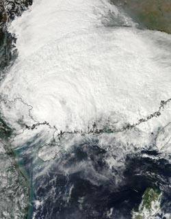
On Nov. 11 at 05:45 UTC, the MODIS instrument aboard NASA's Aqua satellite captured this image of Tropical Storm Haiyan over mainland China. <br>Image Credit: NASA Goddard MODIS Rapid Response Team <br>
NASA's Tropical Rainfall Measuring Mission or TRMM satellite can measure rainfall from space and estimate potential flooding and landslides. An animation of TRMM rainfall data was created at NASA's Goddard Space Flight Center in Greenbelt, Md. to map that rainfall.
A TRMM animation of flood potential from Nov. 2 to Nov. 12 showed the movement of Tropical Storm 30W, Typhoon Krosa and Super-Typhoon Hainan in the western North Pacific Ocean. The animation showed the Tropical Storm 30W drenched the central Philippines days before Super-Typhoon Haiyan made landfall and increased flood potential to “high.”
Haiyan made landfall in northeastern Vietnam and on Nov. 11 at 2100 UTC/4 p.m. EDT with maximum sustained winds of 75 miles/120 km per hour, and continued moving northeast through southern China. Satellite data showed the extent of the tropical storm's cloud cover that stretched from northeastern Vietnam over southeastern China.
On Nov. 10 at 03:30 UTC/Nov. 9 at 10:30 p.m. EDT, the Moderate Resolution Imaging Spectroradiometer or MODIS instrument aboard NASA's Terra satellite showed the center of Typhoon Haiyan was just south of Hainan Island, China in the South China Sea. Later in the day, Haiyan moved north of Hainan Island and headed for a landfall in extreme northeastern Vietnam. Haiyan's maximum sustained winds were near 75 knots/86 mph/138.9 kph. At 1500 UTC/10 a.m. EDT on Nov. 10. At that time it was centered near 19.8 north and 107.9 east, about 160 nautical miles southeast of Hanoi, Vietnam, and moving to the north-northwest at 17 knots/19/5 mph/31.48 kph.
According to RT news.com more than 174,000 households were evacuated, which is about 600,000 people. Haiyan was forecast to make landfall on Nov. 11 at 0000 UTC/8 a.m. Nov 8 local time/(7 p.m. EST Nov. 10), near the Cam Pha District, which is over 100 miles east of Hanoi. Early on Nov. 11, Haiyan made landfall in extreme northeastern Vietnam, as predicted.
On Nov. 11 at 0300 UTC/10 a.m. Vietnam local time/Nov. 10 at 9 p.m. EDT Haiyan was moving over land and its maximum sustained winds were still near 60 knots/69 mph/111.1 kph. The center of the tropical storm was located near 22.2 north and 107.4 east, just 87 nautical miles northeast of Hanoi, Vietnam. Haiyan was moving to the north at 13 knots/14.9 mph/24.0 kph.
Animated enhanced infrared satellite imagery showed the storm was weakening quickly while over land and that bulk of the thunderstorms (and convection) had been pushed north of the center as a result of increasing winds shear from the southwest. On Nov. 11 at 05:45 UTC, the Moderate Resolution Imaging Spectroradiometer or MODIS instrument aboard NASA's Aqua satellite captured an image of Tropical Storm Haiyan over mainland China. The MODIS image showed the extent of cloud cover from northeastern Vietnam over the Guangxi, Guangdong, Hunan, Guizhou, Sichuan, Chongqing, Hubei, Shaanxi, Henan, Anhui and Jaingxi provinces.
Mid-latitude westerly winds moving over China helped weaken the storm. Haiyan is forecast to turn to the east and dissipate in the next day.
Text credit: Rob Gutro
NASA's Goddard Space Flight Cente
Media Contact
All latest news from the category: Earth Sciences
Earth Sciences (also referred to as Geosciences), which deals with basic issues surrounding our planet, plays a vital role in the area of energy and raw materials supply.
Earth Sciences comprises subjects such as geology, geography, geological informatics, paleontology, mineralogy, petrography, crystallography, geophysics, geodesy, glaciology, cartography, photogrammetry, meteorology and seismology, early-warning systems, earthquake research and polar research.
Newest articles

Superradiant atoms could push the boundaries of how precisely time can be measured
Superradiant atoms can help us measure time more precisely than ever. In a new study, researchers from the University of Copenhagen present a new method for measuring the time interval,…

Ion thermoelectric conversion devices for near room temperature
The electrode sheet of the thermoelectric device consists of ionic hydrogel, which is sandwiched between the electrodes to form, and the Prussian blue on the electrode undergoes a redox reaction…

Zap Energy achieves 37-million-degree temperatures in a compact device
New publication reports record electron temperatures for a small-scale, sheared-flow-stabilized Z-pinch fusion device. In the nine decades since humans first produced fusion reactions, only a few fusion technologies have demonstrated…


