NASA satellites see slow-moving Cyclone Rusty before landfall
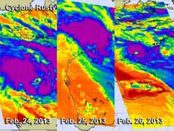
This image shows the development of Cyclone Rusty on Feb. 24 at 0553 UTC (left), Feb. 25 at 1728 UTC (center) and Feb. 26 at 0535 UTC (right). The AIRS instrument aboard NASA's Aqua satellite captured infrared data showing coldest temperatures (purple) and highest cloud tops (and strongest thunderstorms).<br><br>Credit: Credit: NASA/JPL, Ed Olsen<br>
Rusty is a large storm and its slow movement means more rainfall, more flooding potential, increasingly rough surf and a longer period of tropical-storm-force winds along the Pilbara coast.
The Australian Bureau of Meteorology (ABOM) noted on Feb. 26 that forecasters there expect Rusty to resume a southerly track towards the Pilbara coast during Wednesday, Feb. 27 local time. According to ABOM, wind gusts to 120 kilometers per hour (74.5 mph) have already been experienced in Port Hedland and ABOM expects conditions to degrade on Wednesday, Feb. 27.
NASA Satellites Provide Inside Look in Rusty
NASA's Aqua satellite passed over Cyclone Rusty on on Feb. 24, 25 and 26 capturing two different views of the storm that showed forecasters that Rusty was maintaining organization as it nears the coast.
The Atmospheric Infrared Sounder (AIRS) instrument on Aqua gathered three days of infrared data that showed the development of Cyclone Rusty on Feb. 24 at 0553 UTC, Feb. 25 at 1728 UTC and Feb. 26 at 0535 UTC). The AIRS data showed that the storm became more circular and developed an eye on Feb. 26 while still remaining off-shore. AIRS infrared data also showed powerful thunderstorms with cloud top temperatures colder than -63 Fahrenheit (-52 Celsius) surrounding the eye of the storm and dropping heavy rainfall.
On Feb. 26, the Moderate Resolution Imaging Spectroradiometer (MODIS) instrument provided visible image and a clear view of Rusty's eye as it neared Port Hedland, Western Australia.
Tropical cyclone Rusty's winds had increased to hurricane intensity when NASA's TRMM satellite flew directly above on Feb. 26, 2013 at 0654 UTC (1:54 a.m. EST). A rainfall analysis derived from TRMM data found that the heaviest surface rain was coming down at a rate of over 138 mm (~5.4 inches) per hour. This intense band of rainfall was located within strong thunderstorms located in Rusty's western eye wall.
A 3-D image or Rusty's rainfall and cloud heights was created by the TRMM team at NASA's Goddard Space Flight Center in Greenbelt, Md. The data used was from TRMM's Precipitation Radar (PR) data and showed that the tops of some towering thunderstorms in Rusty's eye wall were reaching heights of over 12 km (~7.5 miles).
Where is Rusty?
At 0900 UTC (4 a.m. EST) on Feb. 26, slow-moving Rusty had maximum sustained winds near 75 knots (86.3 mph/138.9 kph). It was centered near 19.4 south and 119.2 east, about 335 nautical miles (385.5 miles 620.4 km) east-northeast of Learmonth, Australia and crawling to the south-southeast at 3 knots (3.4 mph/5.5 kph). Hurricane-force winds extend out 25 miles (28.7 miles/ 46.3 km) from the center, while tropical-storm-force winds extend over 100 nautical miles (115 miles/185 km) from the center making the storm 200 miles (230 miles/370 km) in diameter. Rusty is currently generating 19-foot (5.8 meter)-high-seas.
Watches and Warnings in Effect
On Feb. 26 at 1551 UTC (10:51 a.m. EST/11:51 p.m. WST local time/Australia), the ABOM website noted the following warnings and watches for Cyclone Rusty:
“DFES State Emergency Service (SES) advises of the following community alerts: RED ALERT: People in or near communities between Pardoo and Whim Creek, including Port Hedland and South Hedland need to go to shelter immediately; YELLOW ALERT: People in communities between Wallal and Pardoo, extending inland to Marble Bar need to take action and get ready to shelter from a cyclone; BLUE ALERT: People in communities between Bidyadanga and Wallal and between Whim Creek and Mardie, including Karratha and extending to inland areas including Nullagine and Millstream, need to prepare for cyclonic weather.”
Rusty is now moving along the western edge of a subtropical high pressure system that's centered over central Australia. Forecasters at the Joint Typhoon Warning Center noted that Rusty may intensify over the next 12 hours as the eye nears the coast.
The cyclone will make landfall near Port Hedland and begin to weaken as it interacts with land and wind shear increases.
Media Contact
More Information:
http://www.nasa.govAll latest news from the category: Earth Sciences
Earth Sciences (also referred to as Geosciences), which deals with basic issues surrounding our planet, plays a vital role in the area of energy and raw materials supply.
Earth Sciences comprises subjects such as geology, geography, geological informatics, paleontology, mineralogy, petrography, crystallography, geophysics, geodesy, glaciology, cartography, photogrammetry, meteorology and seismology, early-warning systems, earthquake research and polar research.


Newest articles

Properties of new materials for microchips
… can now be measured well. Reseachers of Delft University of Technology demonstrated measuring performance properties of ultrathin silicon membranes. Making ever smaller and more powerful chips requires new ultrathin…

Floating solar’s potential
… to support sustainable development by addressing climate, water, and energy goals holistically. A new study published this week in Nature Energy raises the potential for floating solar photovoltaics (FPV)…

Skyrmions move at record speeds
… a step towards the computing of the future. An international research team led by scientists from the CNRS1 has discovered that the magnetic nanobubbles2 known as skyrmions can be…

