NASA satellites show heavy rainfall at southeastern coast of Japan
The TRMM satellite captured the rainfall rates occurring within Typhoon Ma-on (before it weakened) on July 19. The red areas are heavy rainfall, falling at a rate of 2 inches (50 mm) per hour. The yellow and green areas indicate moderate rainfall between .78 to 1.57 inches (20-40 mm) per hour. Credit: NASA/SSAI, Hal Pierce<br>
NASA's Aqua satellite passed over Typhoon Ma-on early on July 19, at 0347 UTC (11:47 p.m. EDT on July 18) and imagery from the Atmospheric Infrared Sounder (AIRS) instrument showed a large area of very cold cloud top temperatures from strong thunderstorms to the east and south of the center. As Ma-on moved near the island of Shikoku today, infrared satellite data showed the cloud tops warmed (dropped in height). That's because Ma-on was interacting with the land and wind shear increased, weakening the strength of convection (that builds the thunderstorms).
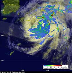
The other satellite that noticed the heavy rainfall associated with Typhoon Ma-on is operated by both NASA and the Japanese Space Agency. That's appropriate because the heavy rains are falling over southeastern Japan. The Tropical Rainfall Measuring Mission (TRMM) satellite observed rainfall rates in Ma-on on July 18, 2011 at 2306 UTC (7:06 p.m. EDT) and again on July 19, 2011 at 0221 UTC (July 18 at 10:21 p.m. EDT).
The rainfall analysis used TRMM's Microwave Imager (TMI) and Precipitation Radar (PR) data from both orbits. The rainfall from early July 19 shows that bands of very heavy rainfall of over 50 mm (~2 inches) were falling over both of the Japanese island of Shikoku and Honshu. At that time, Ma-on's winds had weakened to about 67 kts (~77 mph) making it a category 1 typhoon on the Saffir/Simpson scale.
At 1500 UTC (11 a.m. EDT) on July 19, Typhoon Ma-on's maximum sustained winds were near 55 knots. Tropical storm-force winds extended out to 140 miles from the storm's center. Ma-on was moving to the northeast near 10 knots. It was about 300 miles west-southwest of Yokosuka, Japan near 33.3 North and 134.2 East. At that time, it was brushing the island of Shikoku's southern coast near Muroto Point. Shikoku one of four islands in the four main islands of Japan, and is the smallest. It is located south of Honshu.
Ma-on is expected to continue weakening and is now expected to recurve to the east-southeast and head back to sea sometime on July 20.
Media Contact
More Information:
http://www.nasa.govAll latest news from the category: Earth Sciences
Earth Sciences (also referred to as Geosciences), which deals with basic issues surrounding our planet, plays a vital role in the area of energy and raw materials supply.
Earth Sciences comprises subjects such as geology, geography, geological informatics, paleontology, mineralogy, petrography, crystallography, geophysics, geodesy, glaciology, cartography, photogrammetry, meteorology and seismology, early-warning systems, earthquake research and polar research.


Newest articles

Superradiant atoms could push the boundaries of how precisely time can be measured
Superradiant atoms can help us measure time more precisely than ever. In a new study, researchers from the University of Copenhagen present a new method for measuring the time interval,…

Ion thermoelectric conversion devices for near room temperature
The electrode sheet of the thermoelectric device consists of ionic hydrogel, which is sandwiched between the electrodes to form, and the Prussian blue on the electrode undergoes a redox reaction…

Zap Energy achieves 37-million-degree temperatures in a compact device
New publication reports record electron temperatures for a small-scale, sheared-flow-stabilized Z-pinch fusion device. In the nine decades since humans first produced fusion reactions, only a few fusion technologies have demonstrated…

