NASA satellites see rainfall left behind from Cyclone Lua's landfall
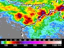
NASA's TRMM satellite can add up rainfall totals from space, and from March 17-19 Cyclone Lua, and it appeared the heaviest rainfall appeared just off the northwestern Australia coast, with rainfall amounts reaching as high as 20 inches/~500 mm (purple). Rainfall amounts seemed to fall off drastically as Lua made landfall with amounts ranging between 4 and 8 inches (~100 to 200 mm) appearing in yellow/green. Credit: NASA/SSAI, Hal Pierce<br>
On Saturday, March 17, 2012, Lua's center crossed the Australia coastline at Pardoo about 3 p.m. (local time/Australia) bringing winds gusting up to 155 mph (250 kph) and heavy rainfall. The Sydney Morning Herald reported that Port Hedland residents experienced maximum sustained winds up to 93 mph (150 kph).
On March 18, 2012, Cyclone Lua continued to move further inland and track south toward Wiluna and Kalgoorlie. At 8 a.m. local time on March 18, the Australian Bureau of Meteorology estimated that Tropical Cyclone Lua was about 137 miles (~220 kilometers) north of Wiluna and was moving south at ~19 mph (30 kph).
NASA's Tropical Rainfall Measuring Mission (TRMM) satellite can add up rainfall totals from space. As it flew over Cyclone Lua between March 17and 19, TRMM calculated rainfall from the storm. The heaviest rainfall appeared to fall just off the northwestern Australia coast, with rainfall amounts there reaching as high as 20 inches (~500 mm). Rainfall amounts seemed to fall off drastically as Lua made landfall, with amounts ranging between 4 and 8 inches (~100 to 200 mm).
Reuters news reported that the sparsely populated area seemed unscathed, there were no injuries and iron ore operations resumed. Port Hedland is the area's largest iron ore terminal and its anchorage was closed for more than two days as Lua made landfall.
The Australian Bureau of Meteorology reported that Cyclone Lua was the strongest cyclone to hit Australia in 2012, and the most powerful since Cyclone Yasi in 2011.
Media Contact
More Information:
http://www.nasa.govAll latest news from the category: Earth Sciences
Earth Sciences (also referred to as Geosciences), which deals with basic issues surrounding our planet, plays a vital role in the area of energy and raw materials supply.
Earth Sciences comprises subjects such as geology, geography, geological informatics, paleontology, mineralogy, petrography, crystallography, geophysics, geodesy, glaciology, cartography, photogrammetry, meteorology and seismology, early-warning systems, earthquake research and polar research.


Newest articles

Superradiant atoms could push the boundaries of how precisely time can be measured
Superradiant atoms can help us measure time more precisely than ever. In a new study, researchers from the University of Copenhagen present a new method for measuring the time interval,…

Ion thermoelectric conversion devices for near room temperature
The electrode sheet of the thermoelectric device consists of ionic hydrogel, which is sandwiched between the electrodes to form, and the Prussian blue on the electrode undergoes a redox reaction…

Zap Energy achieves 37-million-degree temperatures in a compact device
New publication reports record electron temperatures for a small-scale, sheared-flow-stabilized Z-pinch fusion device. In the nine decades since humans first produced fusion reactions, only a few fusion technologies have demonstrated…

