Two NASA Satellites See Cyclone Gino's "Centered" Power
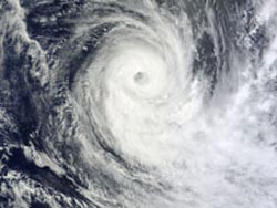
On Feb. 13 at 0505 UTC (12:05 a.m. EST) the MODIS instrument aboard NASA's Terra satellite captured this visible image of Tropical Cyclone Gino in the Indian Ocean. This close-up image clearly shows the ocean surface in the middle of Gino's eye. Credit: NASA Goddard MODIS Rapid Response Team<br>
The Atmospheric Infrared Sounder (AIRS) instrument that flies aboard NASA's Aqua satellite captured an infrared image of Cyclone Gino on Feb. 12 at 1935 UTC (2:35 p.m. EST).
The AIRS temperature data showed Gino maintained a large area of powerful thunderstorms with cold cloud top temperatures and a band of strong thunderstorms wrapping in from the southeast. Cloud top temperatures in both of those areas were as cold as -63 Fahrenheit (-52 Celsius), and are an indication of heavy rainfall. AIRS data during the early morning hours of Feb. 13 indicated cloud top temperatures have warmed slightly, and convection around Gino's center has weakened a little.
At 0505 UTC (12:05 a.m. EST) on Feb. 13 the Moderate Resolution Imaging Spectroradiometer (MODIS) instrument that flies aboard NASA's Terra satellite captured a visible image of Gino. The image clearly showed the ocean surface down through the middle of Gino's ragged eye. According to the Joint Typhoon Warning Center, microwave satellite imagery indicated that the eye is weakening on both low- and mid-levels.
By 1200 UTC (7 a.m. EST), Gino's maximum sustained winds were as high as 85 knots (97.8 mph/157.4 kph) making the storm a Category 2 hurricane on the Saffir-Simpson scale. Gino was centered near 20.6 south latitude and 79.9 east longitude, about 875 nautical miles (1,007 miles/ 1,621 km) south-southeast of Diego Garcia, and far from any land areas. Gino was moving to the south-southeast at 11 knots (12.6 mph/20.3 kph).
Gino continues to head into cooler sea surface temperatures. An approaching trough, or elongated area of low pressure is expected to increase wind shear. Those two factors will adversely affect Gino over the next couple of days.
Text Credit: Rob Gutro
NASA's Goddard Space Flight Center
Media Contact
All latest news from the category: Earth Sciences
Earth Sciences (also referred to as Geosciences), which deals with basic issues surrounding our planet, plays a vital role in the area of energy and raw materials supply.
Earth Sciences comprises subjects such as geology, geography, geological informatics, paleontology, mineralogy, petrography, crystallography, geophysics, geodesy, glaciology, cartography, photogrammetry, meteorology and seismology, early-warning systems, earthquake research and polar research.


Newest articles

Silicon Carbide Innovation Alliance to drive industrial-scale semiconductor work
Known for its ability to withstand extreme environments and high voltages, silicon carbide (SiC) is a semiconducting material made up of silicon and carbon atoms arranged into crystals that is…

New SPECT/CT technique shows impressive biomarker identification
…offers increased access for prostate cancer patients. A novel SPECT/CT acquisition method can accurately detect radiopharmaceutical biodistribution in a convenient manner for prostate cancer patients, opening the door for more…

How 3D printers can give robots a soft touch
Soft skin coverings and touch sensors have emerged as a promising feature for robots that are both safer and more intuitive for human interaction, but they are expensive and difficult…

