NASA Satellites See Cyclone 03A Make Landfall in Somalia
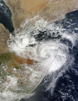
On Nov. 11 at 07:35 UTC/2:35 a.m. EDT NASA's Terra satellite captured this image of Tropical Cyclone 03A over Somalia. <br>Image Credit: NASA Goddard MODIS Rapid Response Team<br>
Somalia is located in the Horn of Africa and its coastline lies on the Arabian Sea and the Gulf of Aden. It is bordered by Ethiopia to the west, and Djibouti to the northwest.
On Nov. 8, NASA's Aqua satellite passed over Tropical Cyclone 03A and the Moderate Resolution Imaging Spectroradiometer or MODIS instrument captured a visible image of the storm at 10:05 UTC/5:05 a.m. EDT. The MODIS image showed a concentrated area of thunderstorms around the center of circulation.
On Nov. 10 at 1500 UTC/10 a.m. EDT, Tropical Cyclone 03A was centered near 8.3 north latitude and 51.2 east longitude about 175 nautical miles south-of Ras Binnah, Somalia. It was moving to the northwest at 4 knots/4.6 mph/7.4 kph and had maximum sustained winds near 35 knots/40 mph/64.8 kph, making it a minimal tropical storm. The strongest convection was pushed west of the center by easterly wind shear. Precipitation radar imagery from NASA's Tropical Rainfall Measuring Mission or TRMM satellite showed the strongest thunderstorms were dropping rainfall at a rate of 1 inch per hour northwest of the center.
On Nov. 11, Tropical Cyclone 03A made landfall in east central Somalia with sustained winds of tropical-storm force. Maximum sustained winds were near 35 knots/40 mph/64.8 kph at the time of landfall. On Nov. 11 at 0300 UTC/Nov. 10 at 10 p.m. EDT, TC03A was centered near 8.5 north and 49.7 east, about 175 nautical miles south-southwest of Ras Binnah, Somalia. It was moving west at 8 knots/9.2 mph/14.8 kph.
On Nov. 11 at 07:35 UTC/2:35 a.m. EDT the MODIS instrument that flies aboard NASA's Terra satellite captured an image of Tropical Cyclone 03A post-landfall and moving over Somalia.
NASA's Tropical Rainfall Measuring Mission satellite called TRMM captured data on rainfall rates within the storm after it made landfall at 0345 UTC on Nov.11. TRMM showed light rainfall throughout most of the tropical storm with areas of moderate rain in the northwestern and east to southeastern quadrants. In the areas of moderate rain, rain was falling at up to 1.18 inches/30 mm per hour. Infrared imagery showed that TC03A maintained its symmetry after it made landfall.
The tropical storm is expected to dissipate over land later today, Nov. 12.
Text credit: Rob Gutro
NASA's Goddard Space Flight Center
Media Contact
All latest news from the category: Earth Sciences
Earth Sciences (also referred to as Geosciences), which deals with basic issues surrounding our planet, plays a vital role in the area of energy and raw materials supply.
Earth Sciences comprises subjects such as geology, geography, geological informatics, paleontology, mineralogy, petrography, crystallography, geophysics, geodesy, glaciology, cartography, photogrammetry, meteorology and seismology, early-warning systems, earthquake research and polar research.


Newest articles

“Nanostitches” enable lighter and tougher composite materials
In research that may lead to next-generation airplanes and spacecraft, MIT engineers used carbon nanotubes to prevent cracking in multilayered composites. To save on fuel and reduce aircraft emissions, engineers…

Trash to treasure
Researchers turn metal waste into catalyst for hydrogen. Scientists have found a way to transform metal waste into a highly efficient catalyst to make hydrogen from water, a discovery that…

Real-time detection of infectious disease viruses
… by searching for molecular fingerprinting. A research team consisting of Professor Kyoung-Duck Park and Taeyoung Moon and Huitae Joo, PhD candidates, from the Department of Physics at Pohang University…

