NASA Satellites Capture Super-Typhoon Utor Before and After Landfall
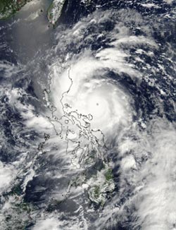
The MODIS instrument on NASA's Aqua satellite captured this stunning image of Super-typhoon Utor approaching the Philippines on Aug. 11 at 05:15 UTC (1:15 a.m. EDT). The eye of the storm is east of the central Philippines. <br>Image Credit: NASA Goddard MODIS Rapid Response Team<br>
Satellite imagery from NASA's Aqua, Terra, TRMM and CloudSat satellites captured information about the powerful Super-Typhoon on Aug. 11 and 12. That data was used by forecasters at the Joint Typhoon Warning Center before and after Utor hit the Philippines.
On Sunday, Aug. 11 at 0719 UTC (3:19 a.m. EDT) NASA's Tropical Rainfall Measuring Mission or TRMM satellite captured rates of heavy rainfall around the storm's center and western quadrant near 1.4 inches per hour. At that time, Utor's rainfall had already started spreading over the northern and central Philippines.
NASA's CloudSat satellite captured a sideways view of Super-Typhoon Utor that sliced through the storm's center on Aug. 11 just before the system hit the Philippines. Cloudsat revealed large amounts of liquid and ice water were abundant at middle and lower levels of the storm system, which were an indication of the storm's strength.
On Sunday, Aug. 11 at 1500 UTC (11 a.m. EDT), Utor's maximum sustained winds were near 130 knots/150mph/241 kph. It was centered just east of the Philippines near 15.7 north and 123.2 east. That's about 169 nautical miles east-northeast of Manila. Utor was moving to the west-northwest at 10 knots/11.5 mph/18.5 kph and headed for landfall.
In less than 13 hours, Super-Typhoon Utor's center crossed the Philippines and the storm weakened into a typhoon.
NASA's Terra satellite passed over the then weakened Typhoon Utor on Monday, Aug. 12 at 02:55 UTC (10:55 p.m. EDT/Aug. 11) as it was moving into the South China Sea. Utor had weakened to a typhoon after crossing the land and its center was near the Lingayen Gulf on the country's western side. Microwave and infrared satellite instrument imagery revealed an eye after Utor emerged over open water.
By 1500 UTC (11 a.m. EDT), Utor's center had already crossed over the Philippines from east to west and emerged in the South China Sea. Maximum sustained winds had dropped to 85 knots/97.8 mph/157.4 kph. Typhoon Utor was located approximately 346 nautical miles/398 miles/641 km southeastward of Hong Kong, near 17.9 north and 117.3 east and has tracked west-northwestward at 14 knots/16 mph/26 kph.
A large number of warnings in remain effect today, Aug. 12, as Typhoon Utor moves through the South China Sea and away from the Philippines. Public storm warning signal #1 is still in effect in the following provinces: Abra, Kalinga, Apayao, Isabela, Aurora, Quirino, Nueva Ecija, Tarlac, Ilocos Norte, Pampanga, Bataan and Zambales. Public storm warning signal #2 is in effect in the provinces of: Nueva Vizcaya, Ifugao, Mt. Province, Ilocos Sur, Benguet, La Union and Pangasinan.
Reuters News Service reported on Aug. 12 that one person died and there were at least 13 people missing. Reuters also noted that the hardest hit town was Casiguran in Aurora province on the Philippines' east coast. Casiguran is the unofficial capital of the northern part of Aurora and is well-known for its beaches and recreation. Utor caused power outages, agricultural damages and landslides.
After weakening over the Philippines, Utor is expected to re-strengthen in the South China Sea before making a final landfall in southeastern China. Forecasters at the Joint Typhoon Warning Center noted that the current track of the storm takes the center between Hainan Island, China and Hong Kong for a landfall on Aug. 14.
On Aug. 13 at 11:15 a.m. EDT (15:15 UTC), the Hong Kong Observatory issued Standby Signal, No. 1 which means that Utor is within 800 kilometers of Hong Kong.
Text credit: Rob Gutro
NASA's Goddard Space Flight Center
Media Contact
All latest news from the category: Earth Sciences
Earth Sciences (also referred to as Geosciences), which deals with basic issues surrounding our planet, plays a vital role in the area of energy and raw materials supply.
Earth Sciences comprises subjects such as geology, geography, geological informatics, paleontology, mineralogy, petrography, crystallography, geophysics, geodesy, glaciology, cartography, photogrammetry, meteorology and seismology, early-warning systems, earthquake research and polar research.


Newest articles

Properties of new materials for microchips
… can now be measured well. Reseachers of Delft University of Technology demonstrated measuring performance properties of ultrathin silicon membranes. Making ever smaller and more powerful chips requires new ultrathin…

Floating solar’s potential
… to support sustainable development by addressing climate, water, and energy goals holistically. A new study published this week in Nature Energy raises the potential for floating solar photovoltaics (FPV)…

Skyrmions move at record speeds
… a step towards the computing of the future. An international research team led by scientists from the CNRS1 has discovered that the magnetic nanobubbles2 known as skyrmions can be…

