NASA satellites analyze Typhoon Soudelor moving toward Taiwan
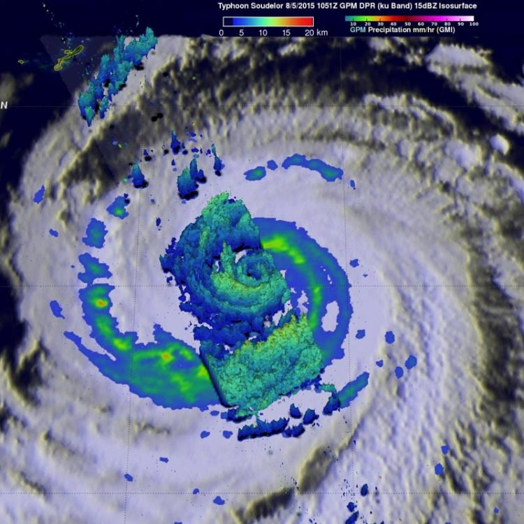
On Aug. 5, the GPM satellite data was used to make a 3-D vertical structure of rainfall within Soudelor. Some storms examined with GPM's radar reached heights of over 12.9 km (about 8 miles) and were dropping rain at a rate of over 87 mm (3.4 inches). Credits: NASA/JAXA/SSAI, Hal Pierce
NASA's Terra satellite passed over Soudelor on August 5, 2015 at 01:45 UTC and the Moderate Resolution Imaging Spectroradiometer (MODIS) instrument captured a visible image of the large storm in the Philippine Sea. The eye appeared to be cloud-filled as bands of thunderstorms spiraled into the center of the storm.
The Global Precipitation Measurement (GPM) mission core observatory, a satellite managed by both NASA and the Japan Aerospace Exploration Agency, took a look at rainfall and cloud heights.
Typhoon Soudelor's sustained winds were 105 knots (about 121 mph) when the GPM core observatory satellite flew above on August 5, 2015 at 1051 UTC. At NASA's Goddard Space Flight Center in Greenbelt, Maryland, a rainfall analysis was made from data collected from GPM's Microwave Imager (GMI) and Dual-Frequency Precipitation Radar (DPR) instruments. The analysis showed that Soudelor was very large and had a well-defined eye. Intense feeder bands are shown spiraling into the center.
Three dimensional radar reflectivity data from GPM's DPR (ku Band) were used to construct a simulated cross section through Typhoon Soudelor's center.
A view from the south showed the 3-D vertical structure of rainfall within Soudelor. Some storms examined with GPM's radar reached heights of over 12.9 km (about 8 miles) and were dropping rain at a rate of over 87 mm (3.4 inches).
On August 5, 2015 at 1500 UTC (11 a.m. EDT), Soudelor was centered near 20.0 North latitude and 132.7 East longitude, about 474 nautical miles (545.5 miles/ 877.8 km) southeast of Kadena Air Base, Okinawa, Japan. It was moving to the west at 10 knots (11.5 mph/18.5 kph). Maximum sustained winds were near 100 knots (115 mph/185 kph).
The Joint Typhoon Warning Center (JTWC) predicts that typhoon Soudelor will continue to be a powerful typhoon and winds are predicted to increase to 120 knots (138 mph) before impacting Taiwan in a couple days. Taiwan's rugged terrain is expected to take its toll on Soudelor but the typhoon is still expected to have wind speeds of 90 knots (103.5 mph) while approaching China.
Media Contact
All latest news from the category: Earth Sciences
Earth Sciences (also referred to as Geosciences), which deals with basic issues surrounding our planet, plays a vital role in the area of energy and raw materials supply.
Earth Sciences comprises subjects such as geology, geography, geological informatics, paleontology, mineralogy, petrography, crystallography, geophysics, geodesy, glaciology, cartography, photogrammetry, meteorology and seismology, early-warning systems, earthquake research and polar research.


Newest articles

Bringing bio-inspired robots to life
Nebraska researcher Eric Markvicka gets NSF CAREER Award to pursue manufacture of novel materials for soft robotics and stretchable electronics. Engineers are increasingly eager to develop robots that mimic the…

Bella moths use poison to attract mates
Scientists are closer to finding out how. Pyrrolizidine alkaloids are as bitter and toxic as they are hard to pronounce. They’re produced by several different types of plants and are…

AI tool creates ‘synthetic’ images of cells
…for enhanced microscopy analysis. Observing individual cells through microscopes can reveal a range of important cell biological phenomena that frequently play a role in human diseases, but the process of…

