NASA Satellite Tracks Tropical Cyclone Lehar Moving Toward India
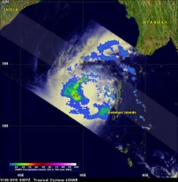
On Nov. 26, 2013. NASA's TRMM satellite saw that rain was falling at a rate greater than 64 mm/~2.5 inches per hour in Lehar's center and in a band of intense rain wrapping around Lehar's northwestern side. <br>Image Credit: NASA/SSAI, Hal Pierce <br>
NASA's Tropical Rainfall Measuring Mission satellite called TRMM flew above tropical cyclone Lehar on November 26, 2013 at 0307 UTC/Nov. 25 at 10:07 p.m. EST and captured rainfall data. Rainfall rates occurring in the storm were derived from TRMM's Microwave Imager (TMI) and Precipitation Radar (PR) instruments.
That data was taken and overlaid on an enhanced visible/infrared image from TRMM's Visible and InfraRed Scanner (VIRS) at NASA's Goddard Space Flight Center in Greenbelt, Md. to create a total picture of rainfall within the tropical cyclone. The TRMM instruments found that rain was falling at a rate greater than 64 mm/~2.5 inches per hour in Lehar's center and in a band of intense rain wrapping around Lehar's northwestern side. Some strong thunderstorms within Lehar were reaching heights above 15.25 km/~9.5 miles.
Warnings are already in effect in India. Northern Andhra Pradesh and southern Odisha are expected to feel Lehar's effects on Wednesday, November 27, when winds are expected to reach up to 91.7 knots/105.6 mph/170 kph.
At 1500 UTC/10 a.m. EST on November 26, Tropical Cyclone Lehar's maximum sustained winds were near 75 knots/86.1 mph/138.9 kph. Tropical-storm-force winds extend up to 100 nautical miles/115.1 miles/185.2 km from the center of the storm or 200 miles/230.2 miles/370.5 km in diameter. Lehar's center was located about 471 nautical miles southeast of Visakhapatnam, India, near 12.9 north and 88.6 east. Lehar was moving to the west-northwest at 9 knots/10.3 mph/16.6 km.
The Joint Typhoon Warning Center or JTWC predicts that Lehar's sustained wind speeds will reach 95 knots/~109 mph on November 27, 2013 and then decrease to about 85 knots/~98 mph before hitting India's east-central coast.
Text credit: Harold F. Pierce
SSAI/NASA Goddard Space Flight Center
Media Contact
All latest news from the category: Earth Sciences
Earth Sciences (also referred to as Geosciences), which deals with basic issues surrounding our planet, plays a vital role in the area of energy and raw materials supply.
Earth Sciences comprises subjects such as geology, geography, geological informatics, paleontology, mineralogy, petrography, crystallography, geophysics, geodesy, glaciology, cartography, photogrammetry, meteorology and seismology, early-warning systems, earthquake research and polar research.


Newest articles
A flexible and efficient DC power converter for sustainable-energy microgrids
A new DC-DC power converter is superior to previous designs and paves the way for more efficient, reliable and sustainable energy storage and conversion solutions. The Kobe University development can…
Technical Trials for Easing the (Cosmological) Tension
A new study sorts through models attempting to solve one of the major challenges of contemporary cosmic science, the measurement of its expansion. Thanks to the dizzying growth of cosmic…

Peptides on Interstellar Ice
A research team led by Dr Serge Krasnokutski from the Astrophysics Laboratory at the Max Planck Institute for Astronomy at the University of Jena had already demonstrated that simple peptides…

