NASA Satellite Sees Typhoon Matmo Brush Eastern Philippines
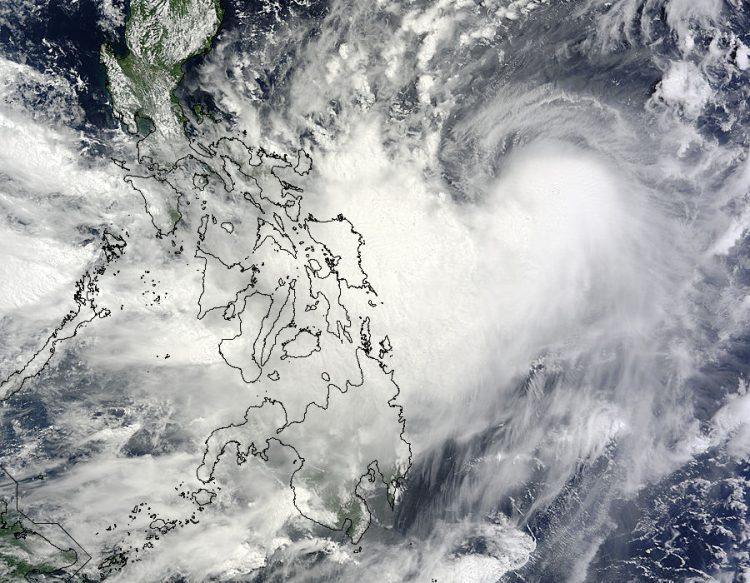
NASA's Terra satellite captured this image of Typhoon Matmo just east of the Philippines on July 20 at 02:15 UTC. Image Credit: NASA Goddard MODIS Rapid Response Team
NASA's Terra satellite passed over Typhoon Matmo on July 20 at 02:15 UTC and the Moderate Resolution Imaging Spectroradiometer or MODIS instrument aboard captured a visible image of the storm.
The MODIS image showed a thick band of thunderstorms west of the storm's center were sweeping over the eastern Philippines.
The Joint Typhoon Warning Center (JTWC) noted that animated multispectral satellite imagery on July 21 showed that convection (rising air that forms thunderstorms) around the center of circulation had strengthened from the previous day.
That stronger convection was evident in a thick band of thunderstorms in the southern quadrant of the storm that wrapped into the center. That same thick band of thunderstorms was also visible on the MODIS image of July 20.
On July 21 at 1500 UTC (11 a.m. EDT) Typhoon Matmo's maximum sustained winds were near 70 knots (80.5 mph/129.6 kph). Matmo was centered near 18.9 north latitude and 125.0 east longitude, about 500 nautical miles south-southwest of Kadena Air Base, Okinawa, Japan.
Matmo is moving to the northwest at 11 knots (12.6 mph/20.3 kph) while intensifying. The Japan Meteorological Agency has issued a yellow alert advisory for Okinawa-honto Chiho that includes thunderstorms and high waves as Matmo draws nearer.
JTWC forecasters said that improving upper-level conditions and warm sea surface temperatures in the Philippine Sea are conducive for further intensification, and they expect Matmo's sustained winds to peak near 105 knots (120.8 mph/194.5 kph) sometime on July 23 as it approaches northern Taiwan.
Text credit: Rob Gutro
NASA's Goddard Space Flight Center
Media Contact
More Information:
http://www.nasa.gov/content/goddard/10w-northwest-pacific-ocean/All latest news from the category: Earth Sciences
Earth Sciences (also referred to as Geosciences), which deals with basic issues surrounding our planet, plays a vital role in the area of energy and raw materials supply.
Earth Sciences comprises subjects such as geology, geography, geological informatics, paleontology, mineralogy, petrography, crystallography, geophysics, geodesy, glaciology, cartography, photogrammetry, meteorology and seismology, early-warning systems, earthquake research and polar research.


Newest articles

Bringing bio-inspired robots to life
Nebraska researcher Eric Markvicka gets NSF CAREER Award to pursue manufacture of novel materials for soft robotics and stretchable electronics. Engineers are increasingly eager to develop robots that mimic the…

Bella moths use poison to attract mates
Scientists are closer to finding out how. Pyrrolizidine alkaloids are as bitter and toxic as they are hard to pronounce. They’re produced by several different types of plants and are…

AI tool creates ‘synthetic’ images of cells
…for enhanced microscopy analysis. Observing individual cells through microscopes can reveal a range of important cell biological phenomena that frequently play a role in human diseases, but the process of…

