NASA Satellite Sees Tropical Depression Peipah Crawling Toward Philippines
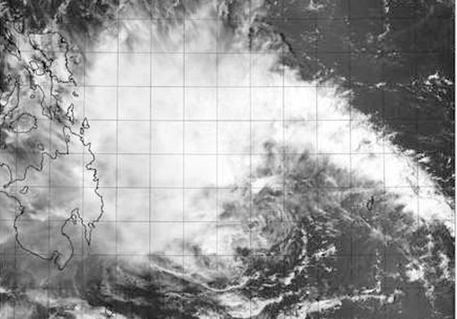
On April 9 at 04:10 UTC/12:10 a.m. EDT, the VIIRS instrument aboard NASA-NOAA's Suomi NPP satellite captured this image of Tropical Depression Peipah slowly approaching the eastern Philippines. Image Credit: NRL/NASA/NOAA
The Visible Infrared Imaging Radiometer Suite or VIIRS instrument aboard Suomi NPP captured a visible, high-resolution image of the storm as it continued moving through the Philippine Sea. The storm appeared disorganized in the image, and the center was difficult to pinpoint on the visible imagery.
VIIRS is a scanning radiometer that collects visible and infrared imagery and radiometric measurements. VIIRS data is used to measure cloud and aerosol properties, ocean color, sea and land surface temperature, ice motion and temperature, fires, and Earth's albedo.
Using animated multispectral satellite imagery, the Joint Typhoon Warning Center observed weakening deep convection (thunderstorms were not developing as quickly) within a broad low-level circulation center.
An image from the Advanced Microwave Sounding Unit (AMSU) showed there is a curved band of thunderstorms over the northern semi-circle. There's also a weak band of thunderstorms over the southwester quadrant of the storm.
The AMSU-A instrument flies aboard NASA's Aqua satellite and is a 15-channel microwave sounder instrument designed primarily to obtain temperatures in the upper atmosphere (especially the stratosphere)
Tropical depression Peipah's maximum sustained winds were near 25 knots/28.7 mph/46.3 kph on April 8 at 1500 UTC/11 a.m. EDT. Peipah is centered near 9.1 north and 129.7 east, or 616 nautical miles/709 miles/1,141 km southeast of Manila, Philippines. The depression slowed down and was moving to the north-northwest at 5 knots/5.7 mph/9.2 kph.
Peipah is in a weak steering environment, that means there are no strong high or low pressure areas nearby to push it one way or another, so it is expected to track slowly in a northwesterly direction for the next several days.
Text credit: Rob Gutro
NASA's Goddard Space Flight Center
Media Contact
All latest news from the category: Earth Sciences
Earth Sciences (also referred to as Geosciences), which deals with basic issues surrounding our planet, plays a vital role in the area of energy and raw materials supply.
Earth Sciences comprises subjects such as geology, geography, geological informatics, paleontology, mineralogy, petrography, crystallography, geophysics, geodesy, glaciology, cartography, photogrammetry, meteorology and seismology, early-warning systems, earthquake research and polar research.


Newest articles

Properties of new materials for microchips
… can now be measured well. Reseachers of Delft University of Technology demonstrated measuring performance properties of ultrathin silicon membranes. Making ever smaller and more powerful chips requires new ultrathin…

Floating solar’s potential
… to support sustainable development by addressing climate, water, and energy goals holistically. A new study published this week in Nature Energy raises the potential for floating solar photovoltaics (FPV)…

Skyrmions move at record speeds
… a step towards the computing of the future. An international research team led by scientists from the CNRS1 has discovered that the magnetic nanobubbles2 known as skyrmions can be…

