NASA Satellite Sees Tropical Cyclone Gillian Return to Remnant Low Status
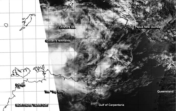
The MODIS instrument aboard NASA's Aqua satellite captured this visible image of Gilian's remnants moving through the Arafura Sea, north of Top End, Northern Territory on March 17, 2014. Image Credit: NRL/NASA
During the week of March 10, Tropical Cyclone Gillian formed in the northern Gulf of Carpentaria and made a brief landfall on the Western Cape York Peninsula, weakening to a remnant low.
After re-emerging in the Gulf, Gillian became a tropical storm again and by March 17 had again weakened to a remnant low as it exited the Gulf and moved into the Arafura Sea.
The MODIS or Moderate Resolution Imaging Spectroradiometer instrument aboard NASA's Aqua satellite captured a visible image of Gillian's remnants moving through the Arafura Sea, north of Top End, Northern Territory at 04:05 UTC/12:05 a.m. EDT on March 17, 2014.
According to the Joint Typhoon Warning Center, an image from NOAA's NOAA-19 polar orbiting satellite on March 17 at 02:50 UTC showed that the low-level circulation center of Gillian is ill-defined and that there is weak banding of thunderstorms around it.
The system is also surrounded by dry air, which is further sapping the storm's ability to generate the thunderstorms that make up the tropical cyclone. Satellite data from the Advanced Scatterometer (ASCAT) that flies aboard the EUMETSAT METOP-A satellite showed that 10 to 15 knot/11.5 to 17.2 mph/ 18.5 to 27.7 kph winds were only seen over the western side of the storm.
On Monday, March 17. 2014, the Australian Bureau of Meteorology noted that Ex-Tropical Cyclone Gillian was located at 10 pm CST (local time, Darwin) near 10.2 south and 134.2 east, about 127.4 miles/205 km north of Maningrida and 127.4 miles/205 km east northeast of Croker Island. Gillian's remnants are moving west at 8.6 knots/9.9 mph//16 km per hour.
ABM expects Ex-Tropical Cyclone Gillian to continue moving to the west and is forecast to remain well to the north of the Top End coast. The north coast of the Northern Territory is not expected to receive gale-force winds.
Satellite data shows that rainfall and convection has been pushed to the western side of the center of circulation. Because of the wind shear, the ABM does not expect strengthening.
Text credit: Rob Gutro
NASA's Goddard Space Flight Center
Media Contact
More Information:
http://www.nasa.govAll latest news from the category: Earth Sciences
Earth Sciences (also referred to as Geosciences), which deals with basic issues surrounding our planet, plays a vital role in the area of energy and raw materials supply.
Earth Sciences comprises subjects such as geology, geography, geological informatics, paleontology, mineralogy, petrography, crystallography, geophysics, geodesy, glaciology, cartography, photogrammetry, meteorology and seismology, early-warning systems, earthquake research and polar research.


Newest articles

Superradiant atoms could push the boundaries of how precisely time can be measured
Superradiant atoms can help us measure time more precisely than ever. In a new study, researchers from the University of Copenhagen present a new method for measuring the time interval,…

Ion thermoelectric conversion devices for near room temperature
The electrode sheet of the thermoelectric device consists of ionic hydrogel, which is sandwiched between the electrodes to form, and the Prussian blue on the electrode undergoes a redox reaction…

Zap Energy achieves 37-million-degree temperatures in a compact device
New publication reports record electron temperatures for a small-scale, sheared-flow-stabilized Z-pinch fusion device. In the nine decades since humans first produced fusion reactions, only a few fusion technologies have demonstrated…

