NASA Satellite Sees Great Freeze Over Great Lakes
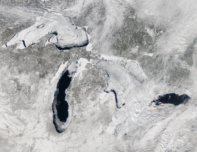
This image, acquired by the Moderate Resolution Imaging Spectroradiometer (MODIS) on NASA's Aqua satellite, shows the Great Lakes on February 19, 2014, when ice covered 80.3 percent of the lakes. Image Credit: Jeff Schmaltz, LANCE/EOSDIS MODIS Rapid Response Team, NASA
Author Craig Childs is not describing an Arctic lake. He's describing the bitterly cold and frozen scene on Lake Superior, during his February 2014 trek on the ice near the coast of Ashland, Wisconsin.
Zoom out to view the scene from a satellite perspective and it's apparent that Lake Superior is not the only lake to feel the freeze. The true-color image above, from the Moderate Resolution Imaging Spectroradiometer (MODIS) on NASA's Aqua satellite, shows the mostly frozen state of the Great Lakes on Feb. 19. On that date, ice spanned 80.3 percent of the lakes, according to NOAA's Great Lakes Environmental Research Laboratory in Ann Arbor, Mich. The ice reached an even greater extent on Feb. 13, when it covered about 88 percent of the Great Lakes – coverage not achieved since 1994, when ice spanned over 90 percent. In addition to this year, ice has covered more than 80 percent of the lakes in only five other years since 1973. The average annual maximum ice extent in that time period is just over 50 percent. The smallest maximum ice cover occurred in 2002, when only 9.5 percent of the lakes froze over.
Scientists say it's understandable that the Great Lakes have had so much ice this year considering the cold temperatures in the region that persisted through the winter. Cold air temperatures remove heat from the water until it reaches the freezing point, at which point ice begins to form on the surface, explained Nathan Kurtz, cryospheric scientist NASA's Goddard Space Flight Center in Greenbelt, Md.
“Persistently low temperatures across the Great Lakes region are responsible for the increased areal coverage of the ice,” Kurtz said. “Low temperatures are also the dominant mechanism for thickening the ice, while secondary factors like clouds, snow, and wind also play a role.”
The freeze this year has local implications, including possible changes to snowfall amounts in the Great Lakes area, explained Walt Meier, also a cryospheric scientist at NASA Goddard. When the lakes are primarily open water, cold air picks up moisture from the relatively warm and moist lake water, often resulting in lake effect snow on the lee side of the lakes, on the eastern and southern shores. When the lakes freeze, the lake effect generally shuts down. “Although this year, they're still picking up a fair amount of snow,” Meier said.
Lake levels could also see an impact by summer, as winter ice cover generally reduces the amount of water available to evaporate during winter months. If that turns out to be the case, it would be “good news for local water supplies, as well as for shipping and recreational use,” Meier said.
It remains to be seen when the Great Lakes will once again freeze to the extent reached in 2014, or at least enough to allow adventurers to reach the ice caves at Lake Superior's Apostle Islands National Lakeshore by foot.
A 2012 study in the Journal of Climate by scientists at NOAA's Great Lakes lab, which included data from MODIS, found that winter season ice cover on Lake Superior has decreased 79 percent from 1973 to 2010. The study also showed that ice cover on the lakes is highly variable and difficult to predict.
The harsh season this year “is a reminder that winters are variable and that weather can always throw an outlier our way,” said Gavin Schmidt, a climatologist and climate modeler at NASA's Goddard Institute for Space Studies in New York.
Related Links:
› NASA's Moderate Resolution Imaging Spectroradiometer
› NOAA Great Lakes Environmental Research Laboratory
Kathryn Hansen
NASA's Earth Science News Team
Media Contact
All latest news from the category: Earth Sciences
Earth Sciences (also referred to as Geosciences), which deals with basic issues surrounding our planet, plays a vital role in the area of energy and raw materials supply.
Earth Sciences comprises subjects such as geology, geography, geological informatics, paleontology, mineralogy, petrography, crystallography, geophysics, geodesy, glaciology, cartography, photogrammetry, meteorology and seismology, early-warning systems, earthquake research and polar research.


Newest articles

Bringing bio-inspired robots to life
Nebraska researcher Eric Markvicka gets NSF CAREER Award to pursue manufacture of novel materials for soft robotics and stretchable electronics. Engineers are increasingly eager to develop robots that mimic the…

Bella moths use poison to attract mates
Scientists are closer to finding out how. Pyrrolizidine alkaloids are as bitter and toxic as they are hard to pronounce. They’re produced by several different types of plants and are…

AI tool creates ‘synthetic’ images of cells
…for enhanced microscopy analysis. Observing individual cells through microscopes can reveal a range of important cell biological phenomena that frequently play a role in human diseases, but the process of…

