NASA Satellite Sees Cyclone Gino's Rainfall Shoved Southward
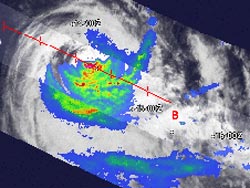
NASA's TRMM satellite flew over Cyclone Gino on Feb. 14 at 3:06 a.m. EST. The heaviest rain was falling at a rate of 2 inches (red) per hour south of the center, and scattered throughout bands of thunderstorms. Credit: NASA/SSAI, Hal Pierce <br>
TRMM flew over Cyclone Gino on Thursday, Feb. 14 at 0806 UTC (3:06 a.m. EST) and measured the rainfall rates occurring throughout the storm. The bulk of the rainfall stretched from south to southeast of the center. The heaviest rain was falling at a rate of 2 inches (50 mm) per hour southeast of the center, and scattered throughout bands of thunderstorms. The bands of thunderstorms were wrapping from the east quadrant into the southwest quadrant of the storm.
As Gino continues in a southerly direction the vertical wind shear that is already affecting the storm's rainfall is expected to increase, according to the forecasters at the Joint Typhoon Warning Center (JTWC).
At 1500 UTC (10 a.m. EST), Cyclone Gino's maximum sustained winds had dropped to 70 knots (80 mph/129.6 kph). Tropical-storm-force winds extend out 110 nautical miles (126.6 miles/203.7 km) from the center of circulation.
Gino was located near 23.9 south latitude and 80.9 east longitude, about 1,110 nautical miles (1,277 miles/2,056 km) south-southeast of Diego Garcia and far from any land areas. Gino was moving to the south-southeast at 12 knots (13.8 mph/22.2 kph).
JTWC expects Gino to track southeastward along the southwestern edge of a subtropical ridge (elongated area) of high pressure where it will encounter strong vertical wind shear between 40 to 60 knots (46 to 69 mph/74 to lll kph) and sea surface temperatures as cool as 24 Celsius (75.2F). Sea surface temperatures of at least 26.6 C (80F) are needed for a tropical cyclone to maintain intensity. Any temperatures cooler than that, will limit thunderstorm development and weaken the storm.
According to JTWC forecasters, Gino should begin transitioning into an extra-tropical storm where the core of the storm changes from a warm core to a cold core, much like a typical mid-latitude low pressure area. Because of the increasing vertical wind shear and cooler sea surface temperatures, Gino may weaken quickly.
Text Credit: Rob Gutro
NASA's Goddard Space Flight Center
Media Contact
More Information:
http://www.nasa.comAll latest news from the category: Earth Sciences
Earth Sciences (also referred to as Geosciences), which deals with basic issues surrounding our planet, plays a vital role in the area of energy and raw materials supply.
Earth Sciences comprises subjects such as geology, geography, geological informatics, paleontology, mineralogy, petrography, crystallography, geophysics, geodesy, glaciology, cartography, photogrammetry, meteorology and seismology, early-warning systems, earthquake research and polar research.


Newest articles

Properties of new materials for microchips
… can now be measured well. Reseachers of Delft University of Technology demonstrated measuring performance properties of ultrathin silicon membranes. Making ever smaller and more powerful chips requires new ultrathin…

Floating solar’s potential
… to support sustainable development by addressing climate, water, and energy goals holistically. A new study published this week in Nature Energy raises the potential for floating solar photovoltaics (FPV)…

Skyrmions move at record speeds
… a step towards the computing of the future. An international research team led by scientists from the CNRS1 has discovered that the magnetic nanobubbles2 known as skyrmions can be…

