NASA satellite sees a warm winter in the Western US
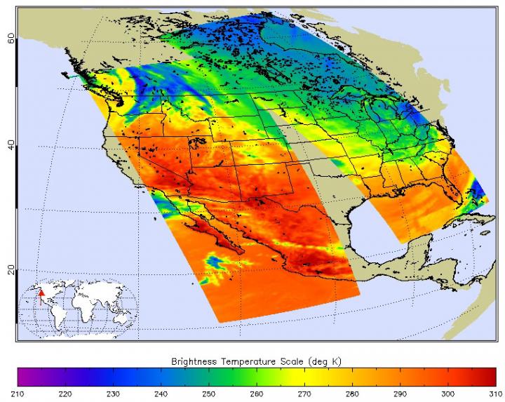
This Feb. 18 infrared image from the AIRS instrument aboard NASA's Aqua satellite shows a warm US West. The darker orange colors indicate warmer temperatures. Credit: NASA JPL, Ed Olsen
Californians have been flaunting their flip-flops and tee shirt weather at friends and relatives on the frigid East Coast. The contrast is extreme, Californians are experiencing their warmest winter since modern record keeping began and Bostonians are staggering through 8 foot and higher snowdrifts. Why?
“It's the weather-controlling polar jet stream – a fast river of wind in the upper atmosphere – that has been locked in an extreme pattern for the past few years,” explained Climatologist Bill Patzert of NASA's Jet Propulsion Laboratory (JPL) in Pasadena, California.
“Rather than circling in a relatively straight path, the jet stream has meandered in great north-south waves. In the west, it's been bulging northward, arguably for the past two winters – a pattern meteorologists have nick named the 'Ridiculously Resilient Ridge.' Over frigid northern Canada, the jet takes a hard right turn and plunges into the upper Midwest and East Coast, plummeting temperatures and creating punishing ice and snow storms.”
Those temperatures are apparent on infrared data taken on Feb. 18 at 18:53 UTC (1:53 p.m. EST) from the Atmospheric Infrared Sounder or AIRS instrument that flies aboard NASA's Aqua satellite. AIRS data are processed and made into false-colored imagery at NASA's JPL.
In the image from Feb. 18, surface temperatures from Washington State, south to California, Nevada, Arizona, New Mexico and western Texas appeared quite warm. Surface temperatures ranged from 290K/62.3F/16.8C to 300K/80.3F/26.8 C.
On Feb. 18, when the AIRS data was taken, the high temperature in Los Angeles, California reached 75F. That was one of 10 days out of the first 20 days of February, where temperatures reached or passed that mark in the city.
Media Contact
All latest news from the category: Earth Sciences
Earth Sciences (also referred to as Geosciences), which deals with basic issues surrounding our planet, plays a vital role in the area of energy and raw materials supply.
Earth Sciences comprises subjects such as geology, geography, geological informatics, paleontology, mineralogy, petrography, crystallography, geophysics, geodesy, glaciology, cartography, photogrammetry, meteorology and seismology, early-warning systems, earthquake research and polar research.


Newest articles

Superradiant atoms could push the boundaries of how precisely time can be measured
Superradiant atoms can help us measure time more precisely than ever. In a new study, researchers from the University of Copenhagen present a new method for measuring the time interval,…

Ion thermoelectric conversion devices for near room temperature
The electrode sheet of the thermoelectric device consists of ionic hydrogel, which is sandwiched between the electrodes to form, and the Prussian blue on the electrode undergoes a redox reaction…

Zap Energy achieves 37-million-degree temperatures in a compact device
New publication reports record electron temperatures for a small-scale, sheared-flow-stabilized Z-pinch fusion device. In the nine decades since humans first produced fusion reactions, only a few fusion technologies have demonstrated…

