NASA satellite sees 2 views of Tropical Storm Soulik over Marianas Islands
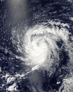
This visible image from July 8 at 3:50 UTC was taken by the MODIS instrument that flies aboard NASA's Aqua satellite shows Tropical Storm Soulik over the Mariana Islands.<br><br>Credit: NASA Goddard MODIS Rapid Response Team<br>
The MODIS or Moderate Resolution Imaging Spectroradiometer instrument that flies aboard NASA's Aqua satellite captured a brilliant visible image of Storm Soulik over the Mariana Islands on July 8 at 3:50 UTC (July 7 at 11:50 p.m. EDT). In the image, Soulik's center could be seen near the northern islands, just west of the long band of thunderstorms covering the island chain.
Around the same time, another instrument aboard Aqua called “AIRS,” or Atmospheric Infrared Sounder captured an infrared look at Soulik. The AIRS infrared data measured cloud top temperatures. AIRS data showed that strong thunderstorms with cloud tops extending high into the troposphere had temperatures as cold as -63F/-52C, and packed the potential for heavy rainfall.
Infrared satellite imagery also showed that Soulik continues to consolidate quickly and it has tightly curved bands of thunderstorms that are wrapping around an eye-like feature near the center of the storm. Satellite microwave imagery showed the eye feature clearly.
On July 8, at 1500 UTC (11 a.m. EDT) Soulik had maximum sustained winds near 55 knots (63 mph/102 kph). Soulik's center was located near 9.2 north latitude and 142.0 east longitude, about 350 nautical miles south-southeast of Iwo Jima. Soulik is moving to the west at 10 knots (11.5 mph//18.5 kph).
Forecasters at the Joint Typhoon Warning center noted that the storm is expected to intensify, and may intensify rapidly. It could reach typhoon strength by tomorrow, July 9.
Soulik is moving away from the Marianas Islands and is expected to continue in a west, then west-northwesterly direction over the next several days. Soulik is currently forecast to track north of the Philippines, and affect northern Taiwan before making landfall in southeastern China (in the Zhejiang Province) later in the week.
Media Contact
More Information:
http://www.nasa.govAll latest news from the category: Earth Sciences
Earth Sciences (also referred to as Geosciences), which deals with basic issues surrounding our planet, plays a vital role in the area of energy and raw materials supply.
Earth Sciences comprises subjects such as geology, geography, geological informatics, paleontology, mineralogy, petrography, crystallography, geophysics, geodesy, glaciology, cartography, photogrammetry, meteorology and seismology, early-warning systems, earthquake research and polar research.


Newest articles

Bringing bio-inspired robots to life
Nebraska researcher Eric Markvicka gets NSF CAREER Award to pursue manufacture of novel materials for soft robotics and stretchable electronics. Engineers are increasingly eager to develop robots that mimic the…

Bella moths use poison to attract mates
Scientists are closer to finding out how. Pyrrolizidine alkaloids are as bitter and toxic as they are hard to pronounce. They’re produced by several different types of plants and are…

AI tool creates ‘synthetic’ images of cells
…for enhanced microscopy analysis. Observing individual cells through microscopes can reveal a range of important cell biological phenomena that frequently play a role in human diseases, but the process of…

