NASA satellite attends the birth of Tropical Storm Bune in Southern Pacific
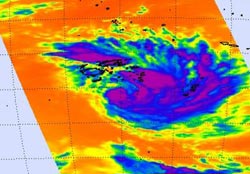
Aqua's Atmospheric Infrared Sounder (AIRS) instrument captured Bune's (purple and blue) high thunderstorm cloud temperatures at 1:35 UTC on March 24, 2011. The strongest thunderstorms were north of the center of circulation (purple). Credit: NASA JPL, Ed Olsen<br>
Bune developed from System 99P, a low pressure area that was about 200 miles southeast of Suva, Fiji yesterday, March 23. The low intensified into tropical depression 19P and today strengthened further into Tropical Storm Bune.
A Tropical Cyclone Alert is in force for Lau, Lomaiviti and nearby smaller islands. A strong wind warning is also in force for the Lau group, Lomaiviti group and nearby smaller islands.
NASA's Aqua satellite captured an infrared image of Bune that showed strongest convection (rapidly rising air that forms the thunderstorms that make up a tropical cyclone) was occurring on the north side of the center of circulation. That's where the cloud top temperatures were the coldest, and the thunderstorms were the highest, and strongest. The low-level circulation center also appears to be consolidating (strengthening) on infrared imagery.
Infrared imagery measures temperatures and not only can it see cold, high cloud tops in tropical cyclones, but also the warm ocean waters that power the cyclones (if the sea surface temperatures are over 80F (26.6 C)). Cold cloud top temperatures provide clues about the power of the thunderstorms in a tropical cyclone. The colder the clouds are, the higher they are, and the more powerful the thunderstorms are that make up the cyclone. Bune's cloud temperatures were colder than – 63F (-52C), indicating very cold, high, strong thunderstorms within.
Today, March 25 at 0900 UTC (5 a.m. EDT), Tropical Storm Bune's maximum sustained winds were up to 45 knots (52 mph/83 kmh) with higher gusts. It was moving away from Fiji and is now located about 260 miles (418 km) southeast of Suva, Fiji near 21.1 South latitude and 179.8 West longitude. Tropical-Storm force winds extended outward from the center up to 50 miles (80 km). It was creating 15 foot (4.5 meter) high waves.
Forecasters at the Joint Typhoon Warning Center are forecasting intensification as the storm moves away from Fiji. It is expected to become extra-tropical far to the north of New Zealand.
Media Contact
More Information:
http://www.nasa.govAll latest news from the category: Earth Sciences
Earth Sciences (also referred to as Geosciences), which deals with basic issues surrounding our planet, plays a vital role in the area of energy and raw materials supply.
Earth Sciences comprises subjects such as geology, geography, geological informatics, paleontology, mineralogy, petrography, crystallography, geophysics, geodesy, glaciology, cartography, photogrammetry, meteorology and seismology, early-warning systems, earthquake research and polar research.


Newest articles

Superradiant atoms could push the boundaries of how precisely time can be measured
Superradiant atoms can help us measure time more precisely than ever. In a new study, researchers from the University of Copenhagen present a new method for measuring the time interval,…

Ion thermoelectric conversion devices for near room temperature
The electrode sheet of the thermoelectric device consists of ionic hydrogel, which is sandwiched between the electrodes to form, and the Prussian blue on the electrode undergoes a redox reaction…

Zap Energy achieves 37-million-degree temperatures in a compact device
New publication reports record electron temperatures for a small-scale, sheared-flow-stabilized Z-pinch fusion device. In the nine decades since humans first produced fusion reactions, only a few fusion technologies have demonstrated…

