NASA's RapidScat sees Typhoon Kilo hold strength
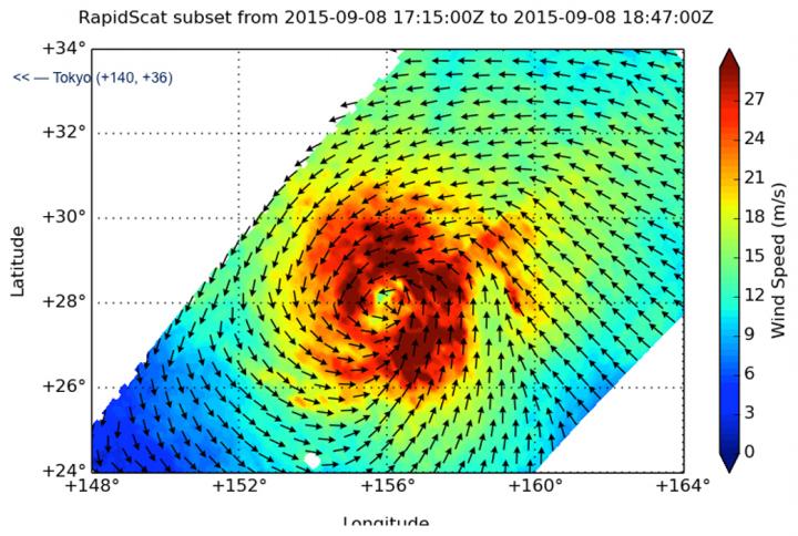
RapidScat showed that Kilo's tropical storm-force winds extended between 170 to 240 nautical miles from the center and strongest sustained winds surrounded the eye at more than 30 meters per second (108 kph/67 mph). Credits: NASA JPL, Doug Tyler
At 1500 UTC (11 a.m. EDT) on September 9, Typhoon Kilo's maximum sustained winds were near 65 knots (75 mph/120.4 kph) making it a Category 1 hurricane on the Saffir-Simpson Scale.
It was centered near 30.8 North latitude and 152.5 East longitude, about 674 nautical miles east southeast of Narita Airport, Japan. Kilo was moving to the northwest at 14 knots (16.1 mph/25.9 kph).
RapidScat showed that tropical storm-force winds extended between 170 to 240 nautical miles (196.5 to 276.4 miles/314.8 to 444.8 km) from the center of circulation. RapidScat data showed that the strongest sustained winds surrounded the eye and were stronger than 30 meters per second (108 kph/67 mph). Kilo's eye is about 9 nautical miles wide.
Infrared satellite imagery shows bands of thunderstorms continued to wrap in the slightly cloud-filled eye with some slight subsidence or sinking air on the western side of the system. Where the air sinks, clouds cannot form.
Kilo was moving northwest, along the southwestern edge of a western extension of a deep layered sub-tropical ridge (elongated area) of high pressure.
Forecasters at the Joint Typhoon Warning Center expect it to maintain current strength over the next day or so. Kilo is curving north and is forecast to transition to an extra-tropical storm as it moves into the Sea of Okhotsk.
Media Contact
All latest news from the category: Earth Sciences
Earth Sciences (also referred to as Geosciences), which deals with basic issues surrounding our planet, plays a vital role in the area of energy and raw materials supply.
Earth Sciences comprises subjects such as geology, geography, geological informatics, paleontology, mineralogy, petrography, crystallography, geophysics, geodesy, glaciology, cartography, photogrammetry, meteorology and seismology, early-warning systems, earthquake research and polar research.


Newest articles

Machine learning algorithm reveals long-theorized glass phase in crystal
Scientists have found evidence of an elusive, glassy phase of matter that emerges when a crystal’s perfect internal pattern is disrupted. X-ray technology and machine learning converge to shed light…

Mapping plant functional diversity from space
HKU ecologists revolutionize ecosystem monitoring with novel field-satellite integration. An international team of researchers, led by Professor Jin WU from the School of Biological Sciences at The University of Hong…

Inverters with constant full load capability
…enable an increase in the performance of electric drives. Overheating components significantly limit the performance of drivetrains in electric vehicles. Inverters in particular are subject to a high thermal load,…

