NASA's RapidScat identifies Typhoon Nangka's strongest side
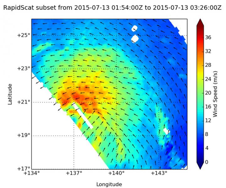
On July 13, the RapidScat instrument observed Nangka's strongest winds were northwest to northeast of the center, reaching speeds of more than 36 meters per second (129 kph/80 mph). Credits: NASA JPL, Doug Tyler
RapidScat gathered surface wind data on the Typhoon Nangka on July 13 from 01:54 to 3:26 UTC (July 12, 9:54 p.m. to 11:26 p.m. EDT).
RapidScat data showed that the strongest sustained winds stretched from northwest to northeast of the center at speeds up to 36 meters per second (129 kph/80 mph).
On July 14 at 03:47 UTC the Atmospheric Infrared Sounder or AIRS instrument aboard NASA's Aqua satellite gathered infrared data on the typhoon. There were powerful thunderstorms with very cold cloud top temperatures surrounding the eye of the storm.
Temperatures colder than -63 Fahrenheit/-52 Celsius that indicated they were high into the troposphere. The image showed a clear area in the eye that allowed the infrared image to show a warmer lower altitude eyewall temperature.
On July 14 at 1500 UTC (11 a.m. EDT), Nangka had sustained winds near 90 knots (103.6 mph/166.7 kph). Those typhoon-force winds extended up to 65 miles from the center.
Nangka was located near 24.4 North latitude and 136.5 East longitude, about 637 nautical miles (733 miles/1,180 km) south-southeast of Iwakuni, Japan. Nangka was moving to the north at 7 knots (8 mph/12.9 kph).
Nangka is moving north and the Joint Typhoon Warning Center forecast calls for the storm to peak at 100 knots(115 mph/185 kph) by July 15. Nangka is then expected to turn west and weaken as it nears Japan. The current forecast track takes the storm to a landfall in western Japan.
Media Contact
All latest news from the category: Earth Sciences
Earth Sciences (also referred to as Geosciences), which deals with basic issues surrounding our planet, plays a vital role in the area of energy and raw materials supply.
Earth Sciences comprises subjects such as geology, geography, geological informatics, paleontology, mineralogy, petrography, crystallography, geophysics, geodesy, glaciology, cartography, photogrammetry, meteorology and seismology, early-warning systems, earthquake research and polar research.


Newest articles

Superradiant atoms could push the boundaries of how precisely time can be measured
Superradiant atoms can help us measure time more precisely than ever. In a new study, researchers from the University of Copenhagen present a new method for measuring the time interval,…

Ion thermoelectric conversion devices for near room temperature
The electrode sheet of the thermoelectric device consists of ionic hydrogel, which is sandwiched between the electrodes to form, and the Prussian blue on the electrode undergoes a redox reaction…

Zap Energy achieves 37-million-degree temperatures in a compact device
New publication reports record electron temperatures for a small-scale, sheared-flow-stabilized Z-pinch fusion device. In the nine decades since humans first produced fusion reactions, only a few fusion technologies have demonstrated…

