NASA's Aqua Satellite Sees Hurricane Vance Headed for Landfall in Western Mexico
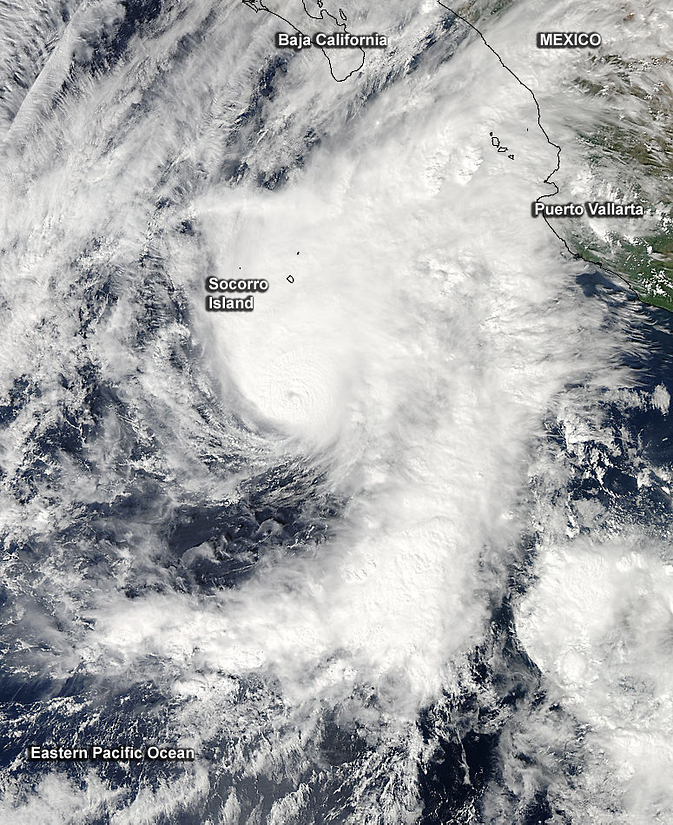
NASA's Aqua satellite saw Hurricane Vance off Mexico's west coast on Nov. 3. Clouds covered Socorro Island and stretched as far east as Puerto Vallarta. Image Credit: NASA Goddard MODIS Rapid Response Team
On Nov. 3 at 20:50 UTC (3:50 p.m. EST) the Moderate Resolution Imaging Spectroradiometer or MODIS instrument that flies aboard NASA's Aqua satellite captured a visible image of Hurricane Vance off Mexico's west coast.
The eastern quadrant of the storm covered Socorro Island and stretched as far east as Puerto Vallarta. Around the center of circulation were a thick band of strong thunderstorms that appeared bright white on the MODIS image. Vance's eye was no longer visible as it had filled in with clouds.
The National Hurricane Center (NHC) reported at 10 a.m. EST (7 a.m. PST/1500 UTC) on Nov. 4 that Vance's maximum sustained winds had decreased to 85 mph (140 kph) and rapid weakening was forecast.
The center of Hurricane Vance was located near latitude 19.3 north and longitude 109.6 west.
That puts the center of Vance about 100 miles (155 km) east-northeast of Socorro Island. Vance is moving toward the north-northeast near 13 mph (20 kph) and is expected to continue for the next couple of days.
Vance is expected to bring large amounts of rainfall to northwestern Mexico. Rainfall totals of 4 to
8 inches with isolated amounts near 12 inches through Wednesday, Nov. 5 over the states of Sinaloa, Nayarit and Durango in western Mexico. NHC noted that swells generated by Vance will be affecting portions of the coast of southwestern Mexico and Baja California Sur today and tonight.
Over the next 24 to 36 hours, Vance could weaken to a tropical depression by the time it reaches the coast of Mexico. Landfall is expected mid-day Wednesday, Nov. 5.
Rob Gutro
NASA's Goddard Space Flight Center
Media Contact
More Information:
http://www.nasa.gov/content/goddard/21e-eastern-pacific/All latest news from the category: Earth Sciences
Earth Sciences (also referred to as Geosciences), which deals with basic issues surrounding our planet, plays a vital role in the area of energy and raw materials supply.
Earth Sciences comprises subjects such as geology, geography, geological informatics, paleontology, mineralogy, petrography, crystallography, geophysics, geodesy, glaciology, cartography, photogrammetry, meteorology and seismology, early-warning systems, earthquake research and polar research.


Newest articles

Superradiant atoms could push the boundaries of how precisely time can be measured
Superradiant atoms can help us measure time more precisely than ever. In a new study, researchers from the University of Copenhagen present a new method for measuring the time interval,…

Ion thermoelectric conversion devices for near room temperature
The electrode sheet of the thermoelectric device consists of ionic hydrogel, which is sandwiched between the electrodes to form, and the Prussian blue on the electrode undergoes a redox reaction…

Zap Energy achieves 37-million-degree temperatures in a compact device
New publication reports record electron temperatures for a small-scale, sheared-flow-stabilized Z-pinch fusion device. In the nine decades since humans first produced fusion reactions, only a few fusion technologies have demonstrated…

