NASA, NOAA satellites help confirm Tropical Storm Fausto as a remnant low
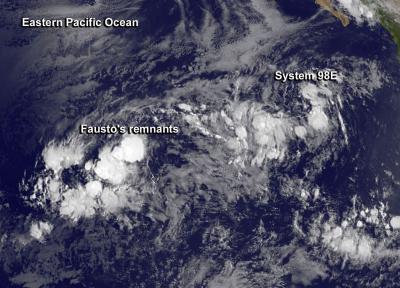
On July 9 at 1500 UTC (11 a.m. EDT) Fausto's circulation was no longer apparent on visible imagery from NOAA's GOES-West satellite and System 98E was located to the east of Fausto. Credit: NASA/NOAA GOES Project
Forecaster Beven at the National Hurricane Center (NHC) noted that “satellite imagery, overnight scatterometer data, and a recent GPM satellite microwave overpass indicate that Fausto has degenerated to a trough of low pressure.”
On July 9 at 1500 UTC (11 a.m. EDT) Fausto's circulation was no longer apparent on visible imagery from NOAA's GOES-West satellite.
The image showed the developing low pressure area known as System 98E, located to the east of Fausto, was slightly more organized today. The GOES-West image was created at NASA/NOAA's GOES Project at NASA's Goddard Space Flight Center in Greenbelt, Md.
The National Hurricane Center issued the final advisory on Fausto at the time of the GOES-West image. At that time, Fausto's remnants were located near 11.7 north latitude and 129.5 west longitude, about 1,505 miles (2,420 km) west-southwest of the southern tip of Baja California.
The maximum sustained winds were near 30 mph (45 kph) and weakening. The NHC expects winds associated with the remnants of Fausto should decrease during the next couple of days. The estimated minimum central pressure was 1007 millibars.
The remnants were moving west-northwest near 17 mph (28 kph) and are expected to continue in a general west-northwestward motion for the next several days. Over that time, they will move through an area of increasing vertical wind shear and mid-level dry air which will help them dissipate.
System 98E is located to the east of Fausto's remnants. The broad low pressure area is generating showers. It is located several hundred miles southwest of the southern tip of the Baja California Peninsula and has become better organized today.
NHC noted that additional slow development is possible during the next day or so before upper-level winds become less friendly for development.
Media Contact
More Information:
http://www.nasa.govAll latest news from the category: Earth Sciences
Earth Sciences (also referred to as Geosciences), which deals with basic issues surrounding our planet, plays a vital role in the area of energy and raw materials supply.
Earth Sciences comprises subjects such as geology, geography, geological informatics, paleontology, mineralogy, petrography, crystallography, geophysics, geodesy, glaciology, cartography, photogrammetry, meteorology and seismology, early-warning systems, earthquake research and polar research.


Newest articles

Silicon Carbide Innovation Alliance to drive industrial-scale semiconductor work
Known for its ability to withstand extreme environments and high voltages, silicon carbide (SiC) is a semiconducting material made up of silicon and carbon atoms arranged into crystals that is…

New SPECT/CT technique shows impressive biomarker identification
…offers increased access for prostate cancer patients. A novel SPECT/CT acquisition method can accurately detect radiopharmaceutical biodistribution in a convenient manner for prostate cancer patients, opening the door for more…

How 3D printers can give robots a soft touch
Soft skin coverings and touch sensors have emerged as a promising feature for robots that are both safer and more intuitive for human interaction, but they are expensive and difficult…

