NASA-NOAA satellite shows fred facing a fizzling future
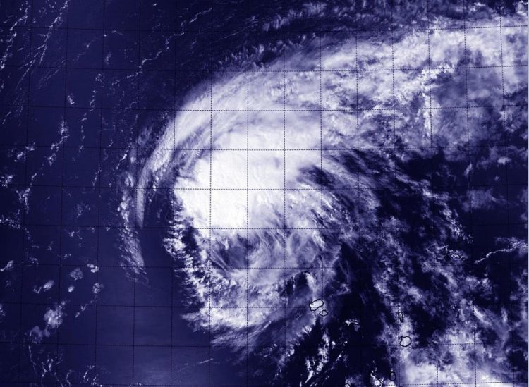
This visible image from NASA-NOAA's Suomi NPP satellite shows thunderstorms diminishing in Tropical Storm Fred on Sept. 1 at 11:04 a.m. EDT. Credits: NASA/NOAA/NRL
Fred continues to quickly weaken. The strongest thunderstorms near the center of the storm decreased in coverage and have become less organized in visible imagery from the Visible Infrared Imaging Radiometer Suite (VIIRS) instrument aboard NASA-NOAA's Suomi NPP satellite. Suomi NPP flew over Fred on September 1 at 11:04 a.m. EDT.
At 11 a.m. EDT (1500 UTC) on September 1, the center of Tropical Storm Fred was located near latitude 18.3 North, longitude 27.0 West. That's about 255 miles (410 km) northwest of the Cape Verde Islands.
Maximum sustained winds have decreased to near 50 mph (85 kph), and the National Hurricane Center (NHC) expects additional weakening during the next 48 hours, and Fred is forecast to become a tropical depression by late Wednesday, September 2. The estimated minimum central pressure is 1003 millibars.
Fred was moving toward the west-northwest near 10 mph (17 kph), and this general motion is expected to continue during the next couple of days.
Fred faces more factors that will make it fizzle over the next several days. The tropical storm is expected to move into an area with increasing southwesterly wind shear (winds that can tear a tropical cyclone apart), some dry air in the mid-levels of the atmosphere, and cooler sea surface temperatures. All of those factors will help weaken the now weaker tropical storm.
The NHC noted that Fred is expected to weaken to a tropical depression in 36 to 48 hours (by September 3) and become a remnant low in 2 to 3 days, but this could occur sooner.
Media Contact
All latest news from the category: Earth Sciences
Earth Sciences (also referred to as Geosciences), which deals with basic issues surrounding our planet, plays a vital role in the area of energy and raw materials supply.
Earth Sciences comprises subjects such as geology, geography, geological informatics, paleontology, mineralogy, petrography, crystallography, geophysics, geodesy, glaciology, cartography, photogrammetry, meteorology and seismology, early-warning systems, earthquake research and polar research.


Newest articles

Silicon Carbide Innovation Alliance to drive industrial-scale semiconductor work
Known for its ability to withstand extreme environments and high voltages, silicon carbide (SiC) is a semiconducting material made up of silicon and carbon atoms arranged into crystals that is…

New SPECT/CT technique shows impressive biomarker identification
…offers increased access for prostate cancer patients. A novel SPECT/CT acquisition method can accurately detect radiopharmaceutical biodistribution in a convenient manner for prostate cancer patients, opening the door for more…

How 3D printers can give robots a soft touch
Soft skin coverings and touch sensors have emerged as a promising feature for robots that are both safer and more intuitive for human interaction, but they are expensive and difficult…

