NASA measuring Tropical Storm Yasi's inland rainfall from space
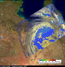
The TRMM satellite flew above the cyclone at 0339 UTC (Feb. 2 at 10:39 p.m. EST/1:39 p.m. Australia local time) collecting data on rainfall rates. Yasi was still dropping moderate to heavy rain over Australia in an area southeast of the Gulf of Carpentaria. The yellow and green areas indicate moderate rainfall between .78 to 1.57 inches per hour. Red areas are heavy rainfall at almost 2 inches per hour. Credit: NASA/SSAI, Hal Pierce<br>
On February 3 at 0300 UTC (Feb. 2 at 10 p.m. EST/1 p.m. Australia local time) Tropical cyclone Yasi continued over land as a tropical storm. Yasi's maximum sustained winds were near 60 knots (69 mph/111 kmh). It was moving west-southwest near 20 knots/23 mph/37 kmh). It was located about 200 miles (321 km) southwest of Cairns, Australia near 19.3 South and 143.4 East.
Just 39 minutes after the position of Yasi's center was determined, the Tropical Rainfall Measuring Mission (TRMM) satellite flew above the cyclone at 0339 UTC (Feb. 2 at 10:39 p.m. EST/1:39 p.m. Australia local time) collecting data on rainfall rates. Yasi had weakened to tropical storm strength but TRMM Microwave Imager (TMI) and Precipitation Radar (PR) data reveal that the storm was still dropping moderate to heavy rain over Australia in an area southeast of the Gulf of Carpentaria.
Just about an hour later, another NASA satellite passed over Yasi capturing the massive size of the strom in a visible image. The Moderate Resolution Imaging Spectroradiometer (MODIS) instrument that flies onboard NASA's Aqua satellite captured data on Yasi at 04:15 UTC (Feb. 2 at 11:15 p.m. EST/2:15 p.m. Australia local time. The center of Yasi had already moved inland and the eye of the storm had become obscured by clouds.
The Australia Bureau of Meteorology (ABoM) website has been updating residents of Yasi's movement and affects. To see the ABoM's radar, visit: http://www.bom.gov.au/products/national_radar_sat.loop.shtml.
At 9:30 a.m. EST (14:30 UTC) on Feb. 3 (or 12:30 a.m. Australia local time on Feb. 4) Yasi was approaching the border of the Northern Territory and had weakened into a tropical depression. The ABoM noted that isolated thunderstorms, heavy rains, flash flooding and damaging winds with gusts greater than 48 knots (55 mph/90 kmh) are possible in the western interior of Queensland. Updates from the ABoM can be found at: www.bom.gov.au.
Media Contact
More Information:
http://www.nasa.govAll latest news from the category: Earth Sciences
Earth Sciences (also referred to as Geosciences), which deals with basic issues surrounding our planet, plays a vital role in the area of energy and raw materials supply.
Earth Sciences comprises subjects such as geology, geography, geological informatics, paleontology, mineralogy, petrography, crystallography, geophysics, geodesy, glaciology, cartography, photogrammetry, meteorology and seismology, early-warning systems, earthquake research and polar research.


Newest articles

Superradiant atoms could push the boundaries of how precisely time can be measured
Superradiant atoms can help us measure time more precisely than ever. In a new study, researchers from the University of Copenhagen present a new method for measuring the time interval,…

Ion thermoelectric conversion devices for near room temperature
The electrode sheet of the thermoelectric device consists of ionic hydrogel, which is sandwiched between the electrodes to form, and the Prussian blue on the electrode undergoes a redox reaction…

Zap Energy achieves 37-million-degree temperatures in a compact device
New publication reports record electron temperatures for a small-scale, sheared-flow-stabilized Z-pinch fusion device. In the nine decades since humans first produced fusion reactions, only a few fusion technologies have demonstrated…

