NASA Measures Typhoon Hagupit's Philippine Rainfall from Space
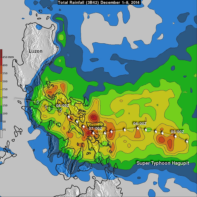
This analysis of rainfall from Dec. 1-8, 2014 showed rainfall totals of over 450 mm (17.5 inches) in a few areas in the eastern Philippines near where Hagupit came ashore. Rainfall amounts of over 200mm (almost 8 inches) were common. Image Credit: NASA/JAXA, SSAI, Hal Pierce
As of Dec. 8, Super Typhoon Hagupit has caused up to 27 deaths. Early reports indicate the Philippines has been spared the widespread destruction caused by Super Typhoon Haiyan in 2013. Hagupit (called Ruby in the Philippines) forward motion slowed on December 4, 2014 before reaching the Philippines. After hitting Samar in the eastern Philippines Hagupit's continued slow movement resulted in high rainfall amounts along the typhoon's track. These high rainfall totals meant that flooding occurred frequently along the typhoon's track.
When NASA/Japan Aerospace Exploration Agency's Tropical Rainfall Measuring Mission (TRMM) satellite flew over Hagupit on December 8, 2014 at 0132 UTC (Dec. 7 at 8:32 p.m. EST) its Microwave Imager (TMI) instrument collected data used in a rainfall analysis. The slow moving typhoon had weakened to a tropical storm but was still dropping light to moderate rainfall. Its center appeared to be in the northern Sibuyan Sea, located between the islands of the central and northern Philippines.
At NASA's Goddard Space Flight Center in Greenbelt, Maryland the TRMM science team created a preliminary analysis of rainfall from December 1 through 8, 2014) using merged satellite rainfall data (from TRMM and other satellites) Rainfall totals of over 450 mm (17.5 inches) were found in a few areas in the
eastern Philippines near where Hagupit came ashore. Rainfall amounts of over 200mm (almost 8 inches) were common.
The International Space Station-RapidScat instrument captured data on Hagupit's winds on Dec. 8 at 08:30 UTC (3:30 a.m. EST/4:30 p.m. Manila local time). The RapidScat image showed sustained winds of 45 to 50 mph east of Luzon, over the Philippine Sea.
On Dec. 8 at 05:35 UTC NASA's Aqua satellite saw the center of Tropical Storm Hagupit in the South China Sea, east of the Philippines Region IV-B of Mimaropa.
By 1500 UTC (10 a.m. EST/11 p.m. local Manila time) on Dec. 8, Hagupit's maximum sustained winds had dropped to 40 knots (46 mph/74 kph). It was centered near 13.4 north longitude and 118.1 east latitude. That's about 157 nautical miles (181 miles/291 km) west-southwest of Manila and in the South China Sea. Hagupit was moving to the west at 7 knots (8 mph/13 kph) and is expected turn to the west-southwest over the next two days.
Hagupit is expected to maintain tropical storm strength over the next day before weakening to a tropical depression upon its approach to southern Vietnam. Forecasters at the Joint Typhoon Warning Center expect that the storm will make landfall near Ho Chi Minh City, Vietnam as a depression early on Dec. 12.
Rob Gutro
NASA's Goddard Space Flight Center
Media Contact
More Information:
http://www.nasa.gov/content/goddard/hagupit-northwestern-pacific-ocean/All latest news from the category: Earth Sciences
Earth Sciences (also referred to as Geosciences), which deals with basic issues surrounding our planet, plays a vital role in the area of energy and raw materials supply.
Earth Sciences comprises subjects such as geology, geography, geological informatics, paleontology, mineralogy, petrography, crystallography, geophysics, geodesy, glaciology, cartography, photogrammetry, meteorology and seismology, early-warning systems, earthquake research and polar research.


Newest articles
Rocks with the oldest evidence yet of Earth’s magnetic field
The 3.7 billion-year-old rocks may extend the magnetic field’s age by 200 million years. Geologists at MIT and Oxford University have uncovered ancient rocks in Greenland that bear the oldest…
Decisive breakthrough for battery production
Storing and utilising energy with innovative sulphur-based cathodes. HU research team develops foundations for sustainable battery technology Electric vehicles and portable electronic devices such as laptops and mobile phones are…

Superradiant atoms could push the boundaries of how precisely time can be measured
Superradiant atoms can help us measure time more precisely than ever. In a new study, researchers from the University of Copenhagen present a new method for measuring the time interval,…

