NASA infrared satellite imagery shows Tropical Storm Mawar strengthening
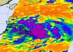
NASA's Aqua satellite passed over tropical storm Mawar on May 31 at 1705 UTC (1:05 p.m. EDT). The image showed improved deep (purple) convection (rising air that form the thunderstorms that make up the tropical depression) wrapping into its low-level circulation center. Credit: NASA JPL, Ed Olsen<br>
By June 1, 2012 at 1500 UTC (10 a.m. EDT), System 95W organized into Tropical Storm Mawar. It had maximum sustained winds near 35 knots (40 mph/65 kph) at that time. It was located about 245 nautical miles east-northeast of Manila, Philippines, near 15.9 North and 124.9 East. It was moving to the northeast at 8 knots (9 mph/14.8 kph) and generating 13-foot (3.9 meter) high waves.
When NASA's Aqua satellite passed overhead, data from the Atmospheric Infrared Sounder (AIRS) gathered infrared data. The image showed improved deep convection (rising air that form the thunderstorms that make up the tropical storm) wrapping into its low-level circulation center.
The AIRS images show the temperature of the cloud tops or the surface of the Earth in cloud-free regions. The coldest cloud temperatures are located around Mawar's center. Those areas have some of the strongest storms. Scientists use the AIRS data to create an accurate 3-D map of atmospheric temperature, water vapor and clouds, all of which are helpful to forecasters. AIRS' infrared signal doesn't penetrate through clouds. Where there are no clouds the AIRS instrument reads the infrared signal from the surface of the ocean waters, revealing warmer temperatures in orange and red.
Forecasters expect Mawar is going to follow a boomerang-shaped path in the western North Pacific, and its outer bands may just graze the east coast of Luzon, Philippines. The main threat from 04W is rough surf along the east-facing coasts of the Philippines over the next several days. By June 4, Mawar is forecast to reach typhoon strength with maximum sustained winds near 85 knots (98 mph/157.4 kph) before weakening.
On June 4 and 5, it is expected to bring rainfall and rough surf to Kadena, southern Japan, Iwo To and Chichi Jima but is expected to weaken by June 5 due to increased wind shear and cooler water temperatures.
Media Contact
More Information:
http://www.nasa.govAll latest news from the category: Earth Sciences
Earth Sciences (also referred to as Geosciences), which deals with basic issues surrounding our planet, plays a vital role in the area of energy and raw materials supply.
Earth Sciences comprises subjects such as geology, geography, geological informatics, paleontology, mineralogy, petrography, crystallography, geophysics, geodesy, glaciology, cartography, photogrammetry, meteorology and seismology, early-warning systems, earthquake research and polar research.


Newest articles

Machine learning algorithm reveals long-theorized glass phase in crystal
Scientists have found evidence of an elusive, glassy phase of matter that emerges when a crystal’s perfect internal pattern is disrupted. X-ray technology and machine learning converge to shed light…

Mapping plant functional diversity from space
HKU ecologists revolutionize ecosystem monitoring with novel field-satellite integration. An international team of researchers, led by Professor Jin WU from the School of Biological Sciences at The University of Hong…

Inverters with constant full load capability
…enable an increase in the performance of electric drives. Overheating components significantly limit the performance of drivetrains in electric vehicles. Inverters in particular are subject to a high thermal load,…

