NASA Infrared Eye Sees Wind Shear Affecting Tropical Storm Kong-Rey
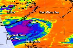
NASA's Aqua satellite captured this infrared image of Tropical Storm Kong-Rey on Aug. 29 at 04:59 UTC when it was just west of Taiwan and Luzon, Philippines. <br><br>Image Credit: NASA/JPL, Ed Olsen<br>
As Tropical Storm Kong-Rey moved past the northern Philippines NASA's Aqua satellite captured an infrared image of the storm that revealed wind shear was taking a toll on the storm.
Tropical cyclones are made up of hundreds of thunderstorms, and the ones with the coldest cloud top temperatures shoot highest in the atmosphere and have a potential to drop heavy rain. The Atmospheric Infrared Sounder instrument that flies aboard NASA's Aqua satellite measured those cloud-top temperatures on Aug. 29 at 04:59 UTC when it flew over the storm from space. The strongest convection, coldest cloud top temperatures and heaviest thunderstorms had been pushed westward from the center as a result of moderate vertical wind shear. Moderate easterly wind shear pushed some of Kong-Rey's thunderstorms over eastern China as the storm's center continues to track over the ocean.
By Aug. 29 at 1500 UTC/11 a.m. EDT, Kong-Rey had moved north of Taiwan. It was centered near 26.9 north and 122.4 east, about 100 nautical miles north-northeast of Taipei, Taiwan. Kong-Rey's maximum sustained winds were near 40 knots/46 mph/74 kph. The tropical storm was moving to the northwest at 4 knots/4.6 mph/7.4 kph, but is expected to turn to the northeast because of an approaching trough (elongated area) of low pressure moving in from the west. That trough will push Kong-Rey toward Japan.
Forecasters at the Joint Typhoon Warning Center or JTWC expect Kong-Rey to transition into a cold-core system and become extra-tropical within the next day. JTWC forecasters expect that Kong-Rey will make landfall in Japan sometime on Aug. 31 just south of Sasebo, Kyushu, Japan.
Text credit: Rob Gutro
NASA's Goddard Space Flight Center
Media Contact
All latest news from the category: Earth Sciences
Earth Sciences (also referred to as Geosciences), which deals with basic issues surrounding our planet, plays a vital role in the area of energy and raw materials supply.
Earth Sciences comprises subjects such as geology, geography, geological informatics, paleontology, mineralogy, petrography, crystallography, geophysics, geodesy, glaciology, cartography, photogrammetry, meteorology and seismology, early-warning systems, earthquake research and polar research.


Newest articles

Security vulnerability in browser interface
… allows computer access via graphics card. Researchers at Graz University of Technology were successful with three different side-channel attacks on graphics cards via the WebGPU browser interface. The attacks…

A closer look at mechanochemistry
Ferdi Schüth and his team at the Max Planck Institut für Kohlenforschung in Mülheim/Germany have been studying the phenomena of mechanochemistry for several years. But what actually happens at the…

Severe Vulnerabilities Discovered in Software to Protect Internet Routing
A research team from the National Research Center for Applied Cybersecurity ATHENE led by Prof. Dr. Haya Schulmann has uncovered 18 vulnerabilities in crucial software components of Resource Public Key…

