NASA infrared data shows Typhoon Bopha re-strengthened in South China Sea
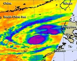
On Dec. 6 at 1:11 p.m. EST/U.S., NASA AIRS infrared data revealed the strongest thunderstorms (purple) within Typhoon Bopha surrounded the center of circulation and were in bands of thunderstorms north and northeast of the center, just skirting the west coast of Luzon, the northern Philippines. AIRS is an instrument that flies aboard NASA's Aqua satellite.<br><br>Credit: NASA JPL, Ed Olsen<br>
NASA's Aqua satellite passed over Bopha on Dec. 6 at 1811 UTC (1:11 p.m. EST, U.S.) and the Atmospheric Infrared Sounder (AIRS) instrument aboard captured an infrared look at the storm. The infrared data revealed where the coldest, highest cloud tops were.
The coldest cloud tops indicate the strongest storms with the heaviest rain, and AIRS data revealed they surrounded the center of circulation and were in bands of thunderstorms north and northeast of the center, just skirting the west coast of Luzon, the northern Philippines. Cloud top temperatures in those areas were colder than -63 Fahrenheit (-52 Celsius). Satellite data showed the Bopha's eye on Dec. 7 was about 11 nautical miles in diameter.
On Dec. 7 at 1500 UTC (10 a.m. EST, U.S.), Typhoon Bopha's maximum sustained winds were back up to 110 knots (126 mph/203.7 kph). Bopha was in the South China Sea near 15.7 north latitude and 116.3 east longitude about 280 nautical miles (322.2 miles/518.6 km) west of Manila, the Philippines.
Bopha was moving to the north-northeast at 9 knots (10.3 mph/16/6 kph), but is expected to make a cyclonic loop over the weekend of Dec. 8 and 9, with its center staying at sea. The west coast of Luzon may experience rough surf over the next several days as Bopha makes its circle.
After Bopha loops over open ocean, it is expected to weaken and turn southwest after the weekend.
Media Contact
More Information:
http://www.nasa.govAll latest news from the category: Earth Sciences
Earth Sciences (also referred to as Geosciences), which deals with basic issues surrounding our planet, plays a vital role in the area of energy and raw materials supply.
Earth Sciences comprises subjects such as geology, geography, geological informatics, paleontology, mineralogy, petrography, crystallography, geophysics, geodesy, glaciology, cartography, photogrammetry, meteorology and seismology, early-warning systems, earthquake research and polar research.


Newest articles

Superradiant atoms could push the boundaries of how precisely time can be measured
Superradiant atoms can help us measure time more precisely than ever. In a new study, researchers from the University of Copenhagen present a new method for measuring the time interval,…

Ion thermoelectric conversion devices for near room temperature
The electrode sheet of the thermoelectric device consists of ionic hydrogel, which is sandwiched between the electrodes to form, and the Prussian blue on the electrode undergoes a redox reaction…

Zap Energy achieves 37-million-degree temperatures in a compact device
New publication reports record electron temperatures for a small-scale, sheared-flow-stabilized Z-pinch fusion device. In the nine decades since humans first produced fusion reactions, only a few fusion technologies have demonstrated…

