NASA infrared data shows Typhoon Bopha re-strengthened in South China Sea
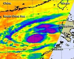
On Dec. 6 at 1:11 p.m. EST/U.S., NASA AIRS infrared data revealed the strongest thunderstorms (purple) within Typhoon Bopha surrounded the center of circulation and were in bands of thunderstorms north and northeast of the center, just skirting the west coast of Luzon, the northern Philippines. AIRS is an instrument that flies aboard NASA's Aqua satellite.<br><br>Credit: NASA JPL, Ed Olsen<br>
NASA's Aqua satellite passed over Bopha on Dec. 6 at 1811 UTC (1:11 p.m. EST, U.S.) and the Atmospheric Infrared Sounder (AIRS) instrument aboard captured an infrared look at the storm. The infrared data revealed where the coldest, highest cloud tops were.
The coldest cloud tops indicate the strongest storms with the heaviest rain, and AIRS data revealed they surrounded the center of circulation and were in bands of thunderstorms north and northeast of the center, just skirting the west coast of Luzon, the northern Philippines. Cloud top temperatures in those areas were colder than -63 Fahrenheit (-52 Celsius). Satellite data showed the Bopha's eye on Dec. 7 was about 11 nautical miles in diameter.
On Dec. 7 at 1500 UTC (10 a.m. EST, U.S.), Typhoon Bopha's maximum sustained winds were back up to 110 knots (126 mph/203.7 kph). Bopha was in the South China Sea near 15.7 north latitude and 116.3 east longitude about 280 nautical miles (322.2 miles/518.6 km) west of Manila, the Philippines.
Bopha was moving to the north-northeast at 9 knots (10.3 mph/16/6 kph), but is expected to make a cyclonic loop over the weekend of Dec. 8 and 9, with its center staying at sea. The west coast of Luzon may experience rough surf over the next several days as Bopha makes its circle.
After Bopha loops over open ocean, it is expected to weaken and turn southwest after the weekend.
Media Contact
More Information:
http://www.nasa.govAll latest news from the category: Earth Sciences
Earth Sciences (also referred to as Geosciences), which deals with basic issues surrounding our planet, plays a vital role in the area of energy and raw materials supply.
Earth Sciences comprises subjects such as geology, geography, geological informatics, paleontology, mineralogy, petrography, crystallography, geophysics, geodesy, glaciology, cartography, photogrammetry, meteorology and seismology, early-warning systems, earthquake research and polar research.


Newest articles

Bringing bio-inspired robots to life
Nebraska researcher Eric Markvicka gets NSF CAREER Award to pursue manufacture of novel materials for soft robotics and stretchable electronics. Engineers are increasingly eager to develop robots that mimic the…

Bella moths use poison to attract mates
Scientists are closer to finding out how. Pyrrolizidine alkaloids are as bitter and toxic as they are hard to pronounce. They’re produced by several different types of plants and are…

AI tool creates ‘synthetic’ images of cells
…for enhanced microscopy analysis. Observing individual cells through microscopes can reveal a range of important cell biological phenomena that frequently play a role in human diseases, but the process of…

