NASA finds strongest storms in weakening Tropical Cyclone Sanba
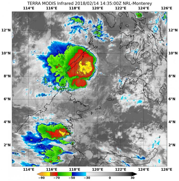
On Feb.14 at 10:45 a.m. EDT (1435 UTC) NASA's Terra satellite found cloud top temperatures of strongest thunderstorms (yellow) in Tropical Cyclone Sanba southeast of Palawan. Temperatures were as cold as or colder than minus 80 degrees Fahrenheit (minus 62.2 Celsius). Credits: NRL/NASA
Infrared light provides valuable temperature data to forecasters and cloud top temperatures give clues about highest, coldest, strongest storms within a hurricane.
On Feb.14 at 10:45 a.m. EDT (1435 UTC) the Moderate Resolution Imaging Spectroradiometer or MODIS instrument aboard NASA's Terra satellite analyzed Tropical Cyclone Sanba's cloud top temperatures in infrared light.
MODIS found a small area where cloud top temperatures of strongest thunderstorms, located in the Sargasso Sea, just southeast of Palawan. Those temperatures were as cold as or colder than minus 80 degrees Fahrenheit (minus 62.2 Celsius).
Cloud top temperatures that cold indicate strong storms that have the capability to create heavy rain.
The Joint Typhoon Warning Center noted at 10 a.m. EDT (1500 UTC) Sanba's maximum sustained winds had dropped to 28.7 mph (25 knots/46.3 kph). Sanba was moving into the South China Sea in a westerly direction at 5.7 mph (5 knots/9.6 kph).
Sanba was located about 480 nautical miles south-southwest of Manila, Philippines near 6.8 degrees north latitude and 119.2 degrees east longitude, about 480 nautical miles south-southwest of Manila, Philippines.
Sanba is crossing the southwestern part of the Sulu Sea, and will pass south of Palawan into the South China Sea. The system will not re-strengthen.
Media Contact
All latest news from the category: Earth Sciences
Earth Sciences (also referred to as Geosciences), which deals with basic issues surrounding our planet, plays a vital role in the area of energy and raw materials supply.
Earth Sciences comprises subjects such as geology, geography, geological informatics, paleontology, mineralogy, petrography, crystallography, geophysics, geodesy, glaciology, cartography, photogrammetry, meteorology and seismology, early-warning systems, earthquake research and polar research.


Newest articles

Bringing bio-inspired robots to life
Nebraska researcher Eric Markvicka gets NSF CAREER Award to pursue manufacture of novel materials for soft robotics and stretchable electronics. Engineers are increasingly eager to develop robots that mimic the…

Bella moths use poison to attract mates
Scientists are closer to finding out how. Pyrrolizidine alkaloids are as bitter and toxic as they are hard to pronounce. They’re produced by several different types of plants and are…

AI tool creates ‘synthetic’ images of cells
…for enhanced microscopy analysis. Observing individual cells through microscopes can reveal a range of important cell biological phenomena that frequently play a role in human diseases, but the process of…

