NASA finds powerful storms in quickly intensifying Tropical Storm Gil
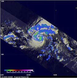
NASA's TRMM satellite traveled above intensifying Tropical Storm Gil on July 31 at 12:55 a.m. EDT. The TRMM satellite pass showed that Gil was already very well organized with intense bands of rain wrapping around the center with rainfall over 5.2 inches per hour.<br><br>Credit: NASA/SSAI, Hal Pierce<br>
NASA's TRMM satellite saw “hot towers” in the storm's center early on July 31, that indicated it would likely strengthen, and it became Tropical Storm Gil hours later.
NASA and the Japan Space Agency's Tropical Rainfall Measuring Mission or TRMM satellite traveled above intensifying tropical storm Gil on July 31, 2013 at 0455 UTC or 12:55 a.m. EDT. The TRMM satellite pass showed that Gil was already very well organized with intense bands of rain wrapping around Gil's future eye.
TRMM's Precipitation Radar (PR) instrument found powerful storms near the center of Gil's circulation dropping rain at the rate of over 131 mm (~5.2 inches) per hour. Those powerful storms were “hot towers.” A “hot tower” is a tall cumulonimbus cloud that reaches at least to the top of the troposphere, the lowest layer of the atmosphere.
It extends approximately nine miles (14.5 km) high in the tropics. These towers are called “hot” because they rise to such altitude due to the large amount of latent heat. Water vapor releases this latent heat as it condenses into liquid. NASA research shows that a tropical cyclone with a hot tower in its eyewall was twice as likely to intensify within six or more hours, than a cyclone that lacked a hot tower.
On Wednesday, July 31 at 1500 UTC/11 a.m. EDT the center of Tropical Storm Gil was located near latitude 13.6 north and longitude 119.9 west, about 920 miles/1,475 km southwest of the southern tip of Baja California, Mexico. Maximum sustained winds were near 60 mph (95 kph). Gil was moving to the west-northwest at 14 mph (22 kph) and had a minimum central pressure of 1,000 millibars.
Tropical storm Gil is predicted by the National Hurricane Center or NHC to move toward the west-northwest and become a minimal hurricane with winds of 75 knots (~86 mph) by August 1.
Media Contact
More Information:
http://www.nasa.govAll latest news from the category: Earth Sciences
Earth Sciences (also referred to as Geosciences), which deals with basic issues surrounding our planet, plays a vital role in the area of energy and raw materials supply.
Earth Sciences comprises subjects such as geology, geography, geological informatics, paleontology, mineralogy, petrography, crystallography, geophysics, geodesy, glaciology, cartography, photogrammetry, meteorology and seismology, early-warning systems, earthquake research and polar research.


Newest articles

Properties of new materials for microchips
… can now be measured well. Reseachers of Delft University of Technology demonstrated measuring performance properties of ultrathin silicon membranes. Making ever smaller and more powerful chips requires new ultrathin…

Floating solar’s potential
… to support sustainable development by addressing climate, water, and energy goals holistically. A new study published this week in Nature Energy raises the potential for floating solar photovoltaics (FPV)…

Skyrmions move at record speeds
… a step towards the computing of the future. An international research team led by scientists from the CNRS1 has discovered that the magnetic nanobubbles2 known as skyrmions can be…

