NASA eyes Typhoon Fanapi approaching Taiwan
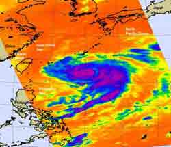
NASA\'s Aqua satellite passed over Typhoon Fanapi on Sept. 17 at 04:45 UTC (12:45 a.m. EDT) and captured this infrared image of its cold cloudtop temperatures. The coldest cloud tops were as cold as -60F, and the imagery showed a tight center circulation. Credit: NASA JPL, Ed Olsen<br>
At 1500 UTC (10 a.m. EDT) on Sept. 17, Typhoon Fanapi's maximum sustained winds were near 85 knots (97 mph). It was centered about 360 nautical miles east-southeast of Taipei, Taiwan near 23.2 North and 127.4 East. It is churning up high seas up to 22 feet.
NASA's Aqua satellite passed over Typhoon Fanapi on September 17 at 04:45 UTC (12:45 a.m. EDT) and captured an infrared image of its cold cloudtop temperatures. The coldest cloud tops were as cold as -60F, and the imagery showed a tight center circulation at that time.
Infrared imagery today continues to show Fanapi consolidating. The typhoon is on the border of becoming a Category 2 typhoon on the Saffir-Simpson hurricane/typhoon scale. Infrared imagery also showed that Fanapi has an 11 mile-wide eye, and that there's a small gap in the eyewall in the northern part of the circulation. Because vertical wind shear is expected to increase over the next 12 to 24 hours, Fanapi is expected to weaken at that time.
Another instrument on NASA's Aqua satellite captured a visible image of Typhoon Fanapi. To see the image that the Moderate Resolution Imaging Spectroradiometer (MODIS) instrument captured of Typhoon Fanapi on September 17 at 04:45 UTC, go to: http://rapidfire.sci.gsfc.nasa.gov/gallery/?2010260-0917/Fanapi.A2010260.0445.
Fanapi is now moving northwest at 6 mph and is expected to make landfall on Sept. 19 during the morning hours local Asia/Taipei time (late Sept. 18 EDT). Fanapi is forecast to cross Taiwan from east to west and then emerge into the Taiwan Strait as a tropical storm and make a final landfall in eastern China on Sept. 20.
Media Contact
More Information:
http://www.nasa.govAll latest news from the category: Earth Sciences
Earth Sciences (also referred to as Geosciences), which deals with basic issues surrounding our planet, plays a vital role in the area of energy and raw materials supply.
Earth Sciences comprises subjects such as geology, geography, geological informatics, paleontology, mineralogy, petrography, crystallography, geophysics, geodesy, glaciology, cartography, photogrammetry, meteorology and seismology, early-warning systems, earthquake research and polar research.


Newest articles

Properties of new materials for microchips
… can now be measured well. Reseachers of Delft University of Technology demonstrated measuring performance properties of ultrathin silicon membranes. Making ever smaller and more powerful chips requires new ultrathin…

Floating solar’s potential
… to support sustainable development by addressing climate, water, and energy goals holistically. A new study published this week in Nature Energy raises the potential for floating solar photovoltaics (FPV)…

Skyrmions move at record speeds
… a step towards the computing of the future. An international research team led by scientists from the CNRS1 has discovered that the magnetic nanobubbles2 known as skyrmions can be…

