NASA eyes Tropical Storm Rafael battering the Leeward Islands
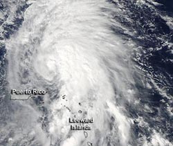
The MODIS instrument aboard NASA's Aqua satellite captured this visible image of Tropical Storm Rafael in the Atlantic Ocean on Oct. 14, 2012, at 1720 UTC (1:20 p.m. EDT). The bulk of Rafael's showers and thunderstorms were concentrated east of the center of circulation.<br><br>Credit: NASA Goddard MODIS Rapid Response Team<br>
The Moderate Resolution Imaging Spectroradiometer (MODIS) instrument aboard NASA's Aqua satellite captured a visible image of Tropical Storm Rafael in the Atlantic Ocean on Oct. 14, 2012 at 1720 UTC (1:20 p.m. EDT). The image clearly showed that the bulk of Rafael's heaviest showers and thunderstorms were concentrated east of the center of circulation.
Those heavy showers are expected to bring between 1 and 3 inches of rainfall over the northern Leeward Islands with isolated totals to 12 inches. Flash flooding and mudslides are always a major concern with this kind of rainfall.
On Oct. 15 at 8 a.m. EDT, Rafael was approaching hurricane strength with maximum sustained winds near 70 mph (110 kph). It was located about 290 miles (465 km) north of San Juan, Puerto Rico, and 680 miles (1,090 miles) south of Bermuda near 22.5 North and 65.5 west. Rafael was moving to the north-northwest at 9 mph (15 kph) and is expected to turn to the north. Satellite imagery on Oct. 15 does not yet reveal an eye.
Forecasters at the National Hurricane Center expect Rafael to approach Bermuda late on Tuesday, Oct. 16.
Meanwhile, heavy surf and swells are expected the eastern facing beaches of the Bahamas, the northern Leeward Islands, and the north and east facing beaches of Puerto Rico. In a couple of days, Rafael will be moving into cooler waters and an area of higher wind shear, but is expected to intensify a little more before that time.
Rafael developed on Friday, Oct. 12 at 7:30 p.m. EDT from System 98L. When it organized into a tropical storm, it was located near 15.0 North and 63.1 West, about 125 miles (200 km) west-southwest of Domincia, causing tropical storm warnings in the U.S. Virgin Islands at that time. When Rafael developed, its maximum sustained winds were near 40 mph, and now forecasters are watching Rafael to see if the storm will become a hurricane.
Media Contact
More Information:
http://www.nasa.govAll latest news from the category: Earth Sciences
Earth Sciences (also referred to as Geosciences), which deals with basic issues surrounding our planet, plays a vital role in the area of energy and raw materials supply.
Earth Sciences comprises subjects such as geology, geography, geological informatics, paleontology, mineralogy, petrography, crystallography, geophysics, geodesy, glaciology, cartography, photogrammetry, meteorology and seismology, early-warning systems, earthquake research and polar research.


Newest articles

High-energy-density aqueous battery based on halogen multi-electron transfer
Traditional non-aqueous lithium-ion batteries have a high energy density, but their safety is compromised due to the flammable organic electrolytes they utilize. Aqueous batteries use water as the solvent for…

First-ever combined heart pump and pig kidney transplant
…gives new hope to patient with terminal illness. Surgeons at NYU Langone Health performed the first-ever combined mechanical heart pump and gene-edited pig kidney transplant surgery in a 54-year-old woman…

Biophysics: Testing how well biomarkers work
LMU researchers have developed a method to determine how reliably target proteins can be labeled using super-resolution fluorescence microscopy. Modern microscopy techniques make it possible to examine the inner workings…

