NASA eyes 2 Eastern Pacific tropical cyclones: 1 up, 1 down
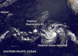
In an infrared image on Aug. 5 at 8 a.m. EDT, NOAA's GOES-15 satellite imagery showed Tropical Depression Gil approaching the Central Pacific Ocean, and Tropical Storm Henriette located to Gil's east.<br><br>Credit: NASA GOES Project<br>
Tropical Depression Gil is more than halfway to Hawaii from Mexico and continues to hold onto depression strength. Meanwhile, NOAA's GOES-15 satellite captured both storms in one image on Aug. 5 at 1200 UTC (8 a.m. EDT). The imagery shows Tropical Storm Henriette dwarfed the smaller Gil.
The infrared image was created by NASA's GOES Project at NASA's Goddard Space Flight Center in Greenbelt, Md. GOES satellite imagery showed a circular concentration of thunderstorms tightly around Gil's small center, while Henriette, located to the east, is several times the size of Gil.
Gil is Tropically “Depressed”
On Monday, Aug. 4 at 11 a.m. EDT (1500 UTC) the center of Tropical Storm Gil was near latitude 13.4 north and longitude 138.6 west, about 1,175 miles/1,890 km east-southeast of Hilo, Hawaii. Gil is moving toward the west-southwest near 8 mph (13 kph) and is expected to continue in that direction for the next day and turn west. Gil's maximum sustained winds were near 30 mph (45 kph). Gil became a depression over the weekend of Aug. 3 and 4 after reaching hurricane status. Gradual weakening is forecast during the next 48 hours. The estimated minimum central pressure is 1007 millibars.
The National Hurricane Center noted that Gil is weakening and will likely cease to qualify as a tropical cyclone in the next day or two. However, if Gil survives the adverse atmospheric environment and holds together, it would track far south of the Hawaiian Island chain over the weekend of Aug. 10 and 11.
NASA Infrared Data Shows a Developing Eye in Henriette
Infrared data from the Atmospheric Infrared Sounder or AIRS instrument that flies aboard NASA's Aqua satellite showed a developing eye in Tropical Storm Henriette. AIRS captured an infrared image of Tropical Storm Henriette on August 5 at 0917 UTC (5:17 a.m. EDT). Strongest storms and heaviest rains appeared around the center where cloud top temperatures exceeded -63F/-52C. The GOES satellite imagery showed that Henriette had grown in size and dwarfs Tropical Depression Gil, located to its west.
Henriette developed from the System 90E which became the eighth tropical depression of the eastern Pacific Ocean hurricane season over the weekend of Aug. 3 and 4.
On Aug. 5 at 11 a.m. EDT (1500 UTC), Tropical Storm Henriette's maximum sustained winds had increased to near 60 mph/95 kph. Further strengthening is forecast by the National Hurricane Center and Henriette is expected to become a hurricane in the next day.
Henriette was located near latitude 12.1 north and longitude 128.2 west, about 1,415 miles (2,280 km west-southwest of the southern tip of Baja California, Mexico. Henriette is moving toward the west near 6 mph/9 kph and is expected to turn west-northwestward Minimum central pressure is near 999 millibars.
Media Contact
More Information:
http://www.nasa.govAll latest news from the category: Earth Sciences
Earth Sciences (also referred to as Geosciences), which deals with basic issues surrounding our planet, plays a vital role in the area of energy and raw materials supply.
Earth Sciences comprises subjects such as geology, geography, geological informatics, paleontology, mineralogy, petrography, crystallography, geophysics, geodesy, glaciology, cartography, photogrammetry, meteorology and seismology, early-warning systems, earthquake research and polar research.


Newest articles

Security vulnerability in browser interface
… allows computer access via graphics card. Researchers at Graz University of Technology were successful with three different side-channel attacks on graphics cards via the WebGPU browser interface. The attacks…

A closer look at mechanochemistry
Ferdi Schüth and his team at the Max Planck Institut für Kohlenforschung in Mülheim/Germany have been studying the phenomena of mechanochemistry for several years. But what actually happens at the…

Severe Vulnerabilities Discovered in Software to Protect Internet Routing
A research team from the National Research Center for Applied Cybersecurity ATHENE led by Prof. Dr. Haya Schulmann has uncovered 18 vulnerabilities in crucial software components of Resource Public Key…

