NASA gets eyeballed from Cyclone Claudia
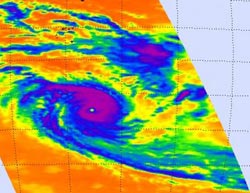
On Dec. 10 at 0841 UTC (3:41 a.m. EST), NASA's Aqua satellite AIRS instrument captured this infrared view of Cyclone Claudia which showed a clear (cloud-free) eye surrounded by powerful thunderstorms (purple).<br><br>Credit: NASA JPL, Ed Olsen<br>
On Dec. 10 at 0841 UTC (3:41 a.m. EST), NASA's Aqua satellite's Atmospheric Infrared Sounder (AIRS) instrument captured an infrared view of Cyclone Claudia which showed a clear eye surrounded by powerful thunderstorms. The thunderstorms that surrounded the eye were high in the troposphere and cloud top temperatures topped -63 Fahrenheit (-52 Celsius).
During that same overpass the Moderate Resolution Imaging Spectroradiometer (MODIS) instrument also aboard Aqua captured a stunning visible image of Claudia that clearly showed an eye.
Claudia became a cyclone over the weekend of Dec. 8 and 9. On Dec. 8, Tropical Cyclone Claudia's winds increased to cyclone strength. During the early morning hours on Dec. 8 NASA's Tropical Rainfall Measuring Mission (TRMM) satellite passed overhead and identified that the heaviest rainfall lay south of the eye of the storm. Rain in that quadrant of the storm was falling at a rate of 30 millimeters (1.2 inches) per hour.
On Sat. Dec. 8, Claudia's maximum sustained winds were near 100 knots (115 mph/185 kph). Claudia was a category 3 cyclone and considered a major storm. It was centered near 14.7 south latitude and 74.6 east longitude, or about 450 nautical miles south-southeast of Diego Garcia. Claudia was moving to the southwest at 4 knots (5 mph).
On Monday, Dec. 10, Cyclone Claudia's maximum sustained winds increased to 105 knots (121 mph/194.5 kph). Claudia had moved about 175 nautical miles in two days and was centered near 18.0 south latitude and 73.8 east longitude, about 625 nautical miles south of Diego Garcia. Claudia continues to move southward at 7 knots (8 mph/13 kph) over open ocean.
Claudia is moving southward along the western edge of ridge (elongated area) of high pressure, and is expected to speed up and turn toward the southeast according to the forecasters at the Joint Typhoon Warning Center.
Claudia may not be giving any NASA satellite the “eye” after another day or two when it runs into cool waters and an area of stronger vertical wind shear.
Media Contact
More Information:
http://www.nasa.govAll latest news from the category: Earth Sciences
Earth Sciences (also referred to as Geosciences), which deals with basic issues surrounding our planet, plays a vital role in the area of energy and raw materials supply.
Earth Sciences comprises subjects such as geology, geography, geological informatics, paleontology, mineralogy, petrography, crystallography, geophysics, geodesy, glaciology, cartography, photogrammetry, meteorology and seismology, early-warning systems, earthquake research and polar research.


Newest articles

Machine learning algorithm reveals long-theorized glass phase in crystal
Scientists have found evidence of an elusive, glassy phase of matter that emerges when a crystal’s perfect internal pattern is disrupted. X-ray technology and machine learning converge to shed light…

Mapping plant functional diversity from space
HKU ecologists revolutionize ecosystem monitoring with novel field-satellite integration. An international team of researchers, led by Professor Jin WU from the School of Biological Sciences at The University of Hong…

Inverters with constant full load capability
…enable an increase in the performance of electric drives. Overheating components significantly limit the performance of drivetrains in electric vehicles. Inverters in particular are subject to a high thermal load,…

