NASA examines newly formed Tropical Depression 3W in 3-D
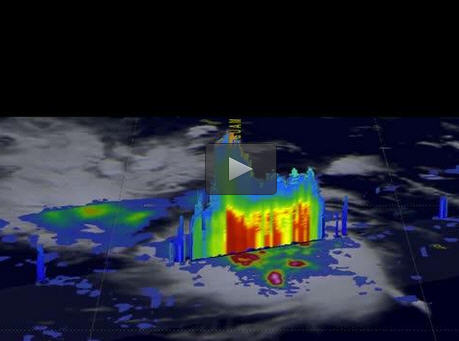
On April 14, 2017 at 1901 UTC (3:01 p.m. EDT) the GPM satellite found some of storms within Tropical Depression 03W were dropping rain at a rate of over 215 mm (8.5 inches) per hour. Some tall convective storm tops were reaching altitudes greater than 17.8 km (11.0 miles). Credits: NASA/JAXA, Hal Pierce
The GPM core observatory satellite had an excellent view of Tropical Depression 03W or TD03W when it flew over on April 14, 2017 at 1901 UTC (3:01 p.m. EDT). The GPM satellite found that the newly formed tropical depression contained some very powerful convective storms.
Intense storms in the middle of the organizing convective cluster were dropping precipitation at extreme rates. GPM's Microwave Imager (GMI) and Dual-Frequency Precipitation Radar (DPR) instruments unveiled tall convective storm towers on the eastern side of this cluster of storms that were dropping rain at a rate of over 215 mm (8.5 inches) per hour.
GPM is a joint mission between NASA and the Japanese space agency JAXA.
A 3-D examination of organizing TD03W's rainfall structure was constructed at NASA's Goddard Space Flight Center in Greenbelt, Maryland by using GPM's Radar (DPR Ku Band). Those data showed that tall convective storm tops on the left side of the cluster were reaching altitudes greater than 17.8 km (11.0 miles).
“Intense downpours in some of these storms were returning radar reflectivity values exceeding 59.7 dBZ to the satellite,” said Hal Pierce, who created the imagery and an animation at NASA Goddard.
“dBZ” means “decibel relative to Z.” It is a logarithmic unit used in weather radar to compare the equivalent reflectivity factor (Z) of a radar signal reflected off a remote object (like raindrops) to the return of a droplet of rain with a diameter of 1 millimeter.
On April 25, 2017 at 1500 UTC (11 a.m. EDT), TD03W had maximum sustained winds near 30 knots (34.5 mph/55.5 kph). It was centered near 13.1 degrees north latitude and 135.5 degrees east longitude, about 256 nautical miles northwest of Yap. TD03W was moving to the west-northwest at 4 knots (4.6 mph/7.4 kph).
The Joint Typhoon Warning Center (JTWC) predicts that TD03W will become slightly more powerful. Sustained maximum wind speeds are expected to reach about 45 knots (~52 mph), which would bring it to tropical storm strength as it curves the northeast.
JTWC then expects vertical wind shear to dampen further intensification and lead to its dissipation on about April 28, 2017.
Media Contact
All latest news from the category: Earth Sciences
Earth Sciences (also referred to as Geosciences), which deals with basic issues surrounding our planet, plays a vital role in the area of energy and raw materials supply.
Earth Sciences comprises subjects such as geology, geography, geological informatics, paleontology, mineralogy, petrography, crystallography, geophysics, geodesy, glaciology, cartography, photogrammetry, meteorology and seismology, early-warning systems, earthquake research and polar research.


Newest articles

Silicon Carbide Innovation Alliance to drive industrial-scale semiconductor work
Known for its ability to withstand extreme environments and high voltages, silicon carbide (SiC) is a semiconducting material made up of silicon and carbon atoms arranged into crystals that is…

New SPECT/CT technique shows impressive biomarker identification
…offers increased access for prostate cancer patients. A novel SPECT/CT acquisition method can accurately detect radiopharmaceutical biodistribution in a convenient manner for prostate cancer patients, opening the door for more…

How 3D printers can give robots a soft touch
Soft skin coverings and touch sensors have emerged as a promising feature for robots that are both safer and more intuitive for human interaction, but they are expensive and difficult…

