NASA Data Reveals Mega-Canyon under Greenland Ice Sheet
Hidden for all of human history, a 460 mile long canyon has been discovered below Greenland's ice sheet. Using radar data from NASA's Operation IceBridge, scientists found the canyon runs from near the center of the island northward to the fjord of the Petermann Glacier.<br>
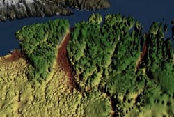
The canyon has the characteristics of a winding river channel and is at least 460 miles (750 kilometers) long, making it longer than the Grand Canyon. In some places, it is as deep as 2,600 feet (800 meters), on scale with segments of the Grand Canyon. This immense feature is thought to predate the ice sheet that has covered Greenland for the last few million years.
“One might assume that the landscape of the Earth has been fully explored and mapped,” said Jonathan Bamber, professor of physical geography at the University of Bristol in the United Kingdom, and lead author of the study. “Our research shows there's still a lot left to discover.”
Bamber's team published its findings Thursday in the journal Science.
The scientists used thousands of miles of airborne radar data, collected by NASA and researchers from the United Kingdom and Germany over several decades, to piece together the landscape lying beneath the Greenland ice sheet.
A large portion of this data was collected from 2009 through 2012 by NASA's Operation IceBridge, an airborne science campaign that studies polar ice. One of IceBridge's scientific instruments, the Multichannel Coherent Radar Depth Sounder, operated by the Center for the Remote Sensing of Ice Sheets at the University of Kansas, can see through vast layers of ice to measure its thickness and the shape of bedrock below.
In their analysis of the radar data, the team discovered a continuous bedrock canyon that extends from almost the center of the island and ends beneath the Petermann Glacier fjord in northern Greenland.
At certain frequencies, radio waves can travel through the ice and bounce off the bedrock underneath. The amount of times the radio waves took to bounce back helped researchers determine the depth of the canyon. The longer it took, the deeper the bedrock feature.
“Two things helped lead to this discovery,” said Michael Studinger, IceBridge project scientist at NASA's Goddard Space Flight Center in Greenbelt, Md. “It was the enormous amount of data collected by IceBridge and the work of combining it with other datasets into a Greenland-wide compilation of all existing data that makes this feature appear in front of our eyes.”
The researchers believe the canyon plays an important role in transporting sub-glacial meltwater from the interior of Greenland to the edge of the ice sheet into the ocean. Evidence suggests that before the presence of the ice sheet, as much as 4 million years ago, water flowed in the canyon from the interior to the coast and was a major river system.
“It is quite remarkable that a channel the size of the Grand Canyon is discovered in the 21st century below the Greenland ice sheet,” said Studinger. “It shows how little we still know about the bedrock below large continental ice sheets.”
The IceBridge campaign will return to Greenland in March 2014 to continue collecting data on land and sea ice in the Arctic using a suite of instruments that includes ice-penetrating radar.
For more information about NASA's Operation IceBridge, visit:
http://www.nasa.gov/icebridge
RELEASE: 13-269
Steve Cole
Headquarters, Washington
202-358-0918
stephen.e.cole@nasa.gov
George Hale
Goddard Space Flight Center, Greenbelt, Md.
301-614-5853
george.r.hale@nasa.gov
Hannah Johnson
University of Bristol, United Kingdom
44-117-928-8896
Hannah.Johnson@bristol.ac.uk
Media Contact
All latest news from the category: Earth Sciences
Earth Sciences (also referred to as Geosciences), which deals with basic issues surrounding our planet, plays a vital role in the area of energy and raw materials supply.
Earth Sciences comprises subjects such as geology, geography, geological informatics, paleontology, mineralogy, petrography, crystallography, geophysics, geodesy, glaciology, cartography, photogrammetry, meteorology and seismology, early-warning systems, earthquake research and polar research.


Newest articles

Security vulnerability in browser interface
… allows computer access via graphics card. Researchers at Graz University of Technology were successful with three different side-channel attacks on graphics cards via the WebGPU browser interface. The attacks…

A closer look at mechanochemistry
Ferdi Schüth and his team at the Max Planck Institut für Kohlenforschung in Mülheim/Germany have been studying the phenomena of mechanochemistry for several years. But what actually happens at the…

Severe Vulnerabilities Discovered in Software to Protect Internet Routing
A research team from the National Research Center for Applied Cybersecurity ATHENE led by Prof. Dr. Haya Schulmann has uncovered 18 vulnerabilities in crucial software components of Resource Public Key…

