NASA Catches Typhoon Trami's Landfall in China
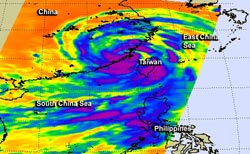
The AIRS instrument aboard NASA's Aqua satellite took this infrared image of Typhoon Trami's landfall on Aug. 21 at 1:59 p.m. EDT. It showed that the most powerful thunderstorms (purple) were tightly wrapped around the storm's center during landfall. Image Credit: NASA/JPL, Ed Olsen<br>
Typhoon Trami made landfall late on Aug. 21, and the storm was captured in infrared light by the Atmospheric Infrared Sounder/AIRS instrument that flies aboard NASA's Aqua satellite. The AIRS image, taken on Aug. 21 at 17:59 UTC/1:59 p.m. EDT showed that the most powerful thunderstorms were tightly wrapped around the storm's center during landfall.
AIRS data also showed bands of powerful thunderstorms feeding into the center from the storm's west and east. The western band stretched over eastern China while the eastern band swept over Taiwan, the Taiwan Strait and South China Sea as Trami made landfall. Cloud top temperatures in those bands of thunderstorms were colder than -63F/-52 C indicating strong uplift in the typhoon. Cloud tops that cold stretched high into the troposphere had the potential to drop heavy rainfall.
Typhoon Trami made landfall in east China's Fujian Province (Thursday morning local time) with maximum sustained winds near 75 knots/86 mph/139 kph. At 2100 UTC/5 p.m. EDT on Aug. 21 it was centered near 25.8 north and 118.9 east, about 107 nautical miles west-northwest of Taipei, Taiwan. It was moving west at 15 knots/17.2 mph/27.8 kph. Trami was downgraded to a tropical storm at 5 a.m. local time, Aug. 22/5 p.m. EDT on Aug. 21, as it moved toward the Jiangxi Province.
According to China Daily, the Fujian Meteorological Center warned of flooding and mudslides. Xinhuanet.com reported that more than 6,000 people were evacuated and over 2,000 vessels were secured in the harbor before Trami approached.
The Joint Typhoon Warning Center issued their final bulletin on Trami and noted that the typhoon is expected to erode due to the frictional effects of land and fully dissipate over land by the early morning hours of Aug. 23.
Text credit: Rob Gutro
NASA's Goddard Space Flight Center
Media Contact
All latest news from the category: Earth Sciences
Earth Sciences (also referred to as Geosciences), which deals with basic issues surrounding our planet, plays a vital role in the area of energy and raw materials supply.
Earth Sciences comprises subjects such as geology, geography, geological informatics, paleontology, mineralogy, petrography, crystallography, geophysics, geodesy, glaciology, cartography, photogrammetry, meteorology and seismology, early-warning systems, earthquake research and polar research.


Newest articles

Properties of new materials for microchips
… can now be measured well. Reseachers of Delft University of Technology demonstrated measuring performance properties of ultrathin silicon membranes. Making ever smaller and more powerful chips requires new ultrathin…

Floating solar’s potential
… to support sustainable development by addressing climate, water, and energy goals holistically. A new study published this week in Nature Energy raises the potential for floating solar photovoltaics (FPV)…

Skyrmions move at record speeds
… a step towards the computing of the future. An international research team led by scientists from the CNRS1 has discovered that the magnetic nanobubbles2 known as skyrmions can be…

