NASA Catches the Brief Life of Tropical Storm Nakri
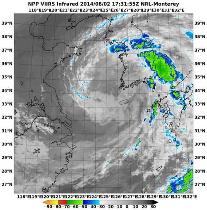
This infrared image of Tropical Storm Nakri was taken from the VIIRS instrument aboard NASA-NOAA's Suomi NPP satellite on Aug.2. VIIRS showed the heaviest precipitation was falling east of the center of circulation. Image Credit: NASA/NOAA
On Saturday, August 2, at 9 p.m. EDT, Nakri's maximum sustained winds were near 40 knots (46 mph/74 kph).
At that time it was centered about 100 nautical miles southeast of Kunsan Air Base, near 35.0 north and 125.0 east. It was moving to the north at 14 knots (16.1 mph/21.9 kph).
When NASA-NOAA's Suomi NPP satellite passed over Nakri on August 2, the Visible Infrared Imaging Radiometer Suite (VIIRS) instrument aboard captured an infrared image of the storm.
The VIIRS instrument showed a tightly wrapped center with fragmented bands of thunderstorms wrapping into the center. VIIRS also showed the heaviest precipitation was falling east of the center of circulation.
VIIRS collects visible and infrared imagery and global observations of land, atmosphere, cryosphere and oceans. VIIRS flies aboard the Suomi NPP satellite, which is managed by both NASA and NOAA.
By 1900 UTC (5 p.m. EDT) on August 3, the Joint Typhoon Warning Center issued its final advisory on Nakri. By that time, Nakri had already weakened to a tropical depression.
It was centered near 36.1 north and 125.8 east, about 15 nautical miles (17.2 miles/27.8 km) northwest of Kunsan Air Base. Later on August 3, Nakri dissipated on approach to the Korean peninsula.
Text credit: Rob Gutro
NASA's Goddard Space Flight Center
Media Contact
More Information:
http://www.nasa.gov/content/goddard/nakri-northwestern-pacific-ocean/All latest news from the category: Earth Sciences
Earth Sciences (also referred to as Geosciences), which deals with basic issues surrounding our planet, plays a vital role in the area of energy and raw materials supply.
Earth Sciences comprises subjects such as geology, geography, geological informatics, paleontology, mineralogy, petrography, crystallography, geophysics, geodesy, glaciology, cartography, photogrammetry, meteorology and seismology, early-warning systems, earthquake research and polar research.


Newest articles

Superradiant atoms could push the boundaries of how precisely time can be measured
Superradiant atoms can help us measure time more precisely than ever. In a new study, researchers from the University of Copenhagen present a new method for measuring the time interval,…

Ion thermoelectric conversion devices for near room temperature
The electrode sheet of the thermoelectric device consists of ionic hydrogel, which is sandwiched between the electrodes to form, and the Prussian blue on the electrode undergoes a redox reaction…

Zap Energy achieves 37-million-degree temperatures in a compact device
New publication reports record electron temperatures for a small-scale, sheared-flow-stabilized Z-pinch fusion device. In the nine decades since humans first produced fusion reactions, only a few fusion technologies have demonstrated…

